
The Dictionary of Sydney was archived in 2021.
South Head
Citation
Persistent URL for this entry
To cite this entry in text
To cite this entry in a Wikipedia footnote citation
To cite this entry as a Wikipedia External link
South Head
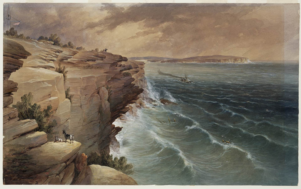
South Head is the [media]peninsular and sandstone headland that marks the entrance to Port Jackson. Before 1788 it was intensively used by Aboriginal people as a base for settlement, fishing, shellfish collection, art and associated rituals. From the first European settlement onwards, the cliffs of South Head were the landmark for arrival at Sydney. A lookout and later a signal station were established to advise the early colony of arriving ships, and over time a flag staff, stone tower, night cauldron and the Macquarie lighthouse were built to signal to incoming ships. The history of South Head was marked by shipwrecks (leading to the erection of a second lighthouse) and over a century of fortifications to defend the harbour, before the area was turned into a national park and recreation area. It has long been one of the city's most visited locations.
The area extends from Outer South Head (where the Macquarie lighthouse is) to Inner South Head (where the Hornby lighthouse is), an area which includes The Gap and HMAS Watson and is wrapped around the village and suburb of Watsons Bay. The name South Head is today often used to describe Inner South Head.
Aboriginal South Head
The natural vegetation [1] of this area was the mixed eucalypt forest of the Sydney sandstone complex, ranging from tall forest with denser undergrowth on the slopes and gullies leading into the harbour, to the more open, lower, sparse woodland on the exposed cliff and ridge tops. The most exposed cliff tops carried only a heath flora.
This varied range of flora provided edible plant foods and fauna for Aboriginal people. But the main settlement use of the South head before Europeans was for fishing and shellfish collection.
Well-studied, though now mostly invisible, are the rock engravings at South Head in Watsons Bay, the site of the earliest reports by Europeans of Aboriginal art in Australia. [2] They stretch along the cliff top, and along the areas accessible to Sydney harbour, with a significant number at Inner South Head itself, which was a major Aboriginal fishing site. Subjects include humans, bandicoots, kangaroos and wallabies, and marine fauna – fish, whales, sharks – as well as geometric shapes.
Camp Cove was an important base for Aboriginal people as a camp and a site to launch the canoes used in fishing, which extended out to the ocean below the cliffs. [3]
Aboriginal names for the area were recorded as Woo-la-ra or Tarralbe for Outer South Head, Burra-wa-ra or Barraory for Inner South Head, and Mit-ta-la (or Metallar) for Green Point (Laings Point). A young Aboriginal informant, Nanbarry, made an unsubstantiated claim in 1790 that this area was 'famed for its great engagements' and that here were the graves of the dead.
The lookout and its successors
In 1790 Outer South Head was chosen by the European colonists as the best site to signal incoming ships, and to signal news of their arrival back to Sydney town.
The early colony was desperate for the arrival of supplies from an expected second fleet, but such a support expedition would be travelling to Botany Bay, and would not know of the removal of settlement to Port Jackson. Therefore each week for the first 18 months of settlement, a party of marines was sent overland to Botany Bay to see if any vessel had arrived there. [4] Captain John Hunter suggested that a lookout at Outer South Head would be a better use of resources. From here a permanent guard would watch out for arriving ships, raising a flag both to give the ships a sign of the new location of the settlement, and to notify the colony of the imminent arrival of the long-awaited ships. Hunter explained:
The governor approved my proposals. I went down with six men, and was accompanied by Mr. White and Mr. Worgan, the surgeons of the settlement and Sirius. We erected a flag-staff, and lived in a tent for ten days, in which time we completed a tolerably good house. [5]
The flag staff was visible from the higher land bordering Sydney Cove – the eastern side where the government farm was sited, and the present Observatory Hill on the western side. The location chosen had to be high enough to be seen from Sydney, and as far east as possible to gain the maximum sightlines to and from the sea to the south.
The location that best meets these criteria is that marked by today's signal station and the adjacent flag staff at Dunbar Head. The sightline goes over the extremity of Ben Buckler head, north of Bondi beach. Spotting the flag staff from such a distance at sea would be more challenging, but any vessel would be seen and would subsequently see the flag staff after finding Botany Bay unoccupied and sailing on. [6]
William Bradley took over command at the lookout on 29 January 1790, and five days later on 3 February Governor Phillip paid a visit of inspection, accompanied by Bennelong. [7]
The lookout came into its own when the Supply was sighted, on return from Norfolk Island, briefly raising false expectations in the colony. [8] But at least the first test of the flag staff idea showed the colony that it worked!
Charge of the lookout was then given to Daniel Southwell, who had been a midshipman on the Sirius. His journal as well as his letters home to England give us a detailed view of the first European settlement at South Head. [9]
According to Southwell, there were up to eleven men stationed there. They took turns in four hour shifts throughout all hours of daylight, to watch for shipping. They lived further down the slope at what was later called Watsons Bay.
One boat, when available, had to serve the whole group and convey additional personnel, food and supplies to the lookout crew, and messages and personnel back to Sydney Cove. When the boat was otherwise in use they had to follow a foot track along the line of today's New South Head Road. [10] The dangers of the open boat were evident when a whale overturned it in July 1790, drowning one of the lookout staff.
The charm of the situation was greater for visitors than for those stationed there. On 23 July 1791 William Norris and William Roberts, privates in the marines, were sent there as a punishment. [11] In 1797 a soldier posted to the lookout went missing, and his body was found two days later, on Christmas Day, in an abused state. [12] In 1800, under Governor King, a political plot of Irish nationalists was uncovered, in which it was suggested that 'many of the soldiers would be ready to join and take the guns to South Head and other places of security'. [13]
The lookout fulfilled its purpose on 3 June 1790 with the sighting of the Lady Juliana, the first vessel of the Second Fleet. The flag was raised and Sydney settlement responded. [14] Thereafter in private and public records, the arrival of a ship is noted by a phrase such as 'the signal was made at the South Head', or 'the signal for a sail in the offing was flown at South Head'.
By August 1790 Governor Phillip had decided a more substantive marker was needed to guide arriving ships to the new settlement, and a brick column on a base of locally quarried stone was erected on the high land adjacent to the flag staff and just south of the shelter of the lookout staff. [15] A plan showed it to be four feet by four feet (120 centimetres by 120 centimetres), on a platform six feet high (180 centimetres), and the column, sometimes called the 'obelisk' or 'pyramid', is shown on early illustrations and maps. [16]
Periodic repairs and improvements continued over the years. [17] From 1832, the staff at the site used a system of signal flags to send messages to Sydney and beyond.
A more [media]substantial signal station was constructed from 1838. The building remains in use by volunteer coast guards, who man radios 24 hours a day for the benefit of small and recreational boats. The site has thus maintained its role for over two centuries, for much of that time from the same building.

Shipwrecks, lights and lighthouses
The staff of the lookout erected a signal and warning light in a cauldron each night for shipping, and a fee was charged to ships entering the harbour to pay for this. [18]
In 1816 Governor Macquarie initiated the construction of the Macquarie lighthouse. Operating from 1818, it was replaced with the current building in 1883.
The merchant ship Dunbar hit the rocks just north of the signal station on the night of 20 August 1857. Attempting to turn through the heads in minimal visibility after passing the Macquarie lighthouse, the vessel was kept further south than intended by currents, and it hit the rocks with the loss of all but one of its 122 passengers and crew. Two months later the Catherine Adamson foundered at North Head with the loss of 21 lives.
In response, urgent action was taken to mark the entrance to the harbour with another lighthouse at Inner South Head. The Hornby light (also called the Lower light) was painted red and white to distinguish it by day from the Macquarie lighthouse. It was operational by 1858, and named after the family of Governor Denison's wife. Adjacent sandstone cottages for the lighthouse staff were built in 1857–61 and extended in 1877–78. Lighting was initially fuelled by kerosene, then gas from 1904, and from 1933 unmanned automated electric light, after which the military took over the lighthouse keeper's quarters.
Fortifications
There have been frequent recommendations for the fortification of South Head to help defend Sydney harbour from attack, however there were few actual constructions of fortifications and even fewer installations of artillery until World War II. [19]
In 1804 Governor King suggested: [20]
in order to fortify the harbour it would be necessary to have a battery of twelve eighteen-pounders on the inner South Head, one side to face the east.
The military road built by Governor Macquarie to Outer South Head in 1813 would have allowed the transport of men and equipment if required, but no permanent garrison was established. Numerous nineteenth century reports on the defence needs of Sydney harbour made recommendations that included the fortification of South Head and gun emplacements at Inner South Head in particular, but action on these was slow. Reports recommended the building of a fort, the need for an observation tower, the extension of the military road to the Hornby light and the installation of a boom across the harbour from Inner South Head.
Some construction of fortifications at South Head may have started by 1841, but fortifications were only completed in 1854, accelerated by the threats of the Crimean War. After this defence priorities were reassessed and it seems no artillery was installed at that time.
Following the departure of British troops from the colony in 1870, work resumed on fortifications at South Head in 1871, and by 1874 there was actual artillery in place. This consisted of three 10-inch, two 9-inch and five 80-pounder guns, supplemented in 1878 by torpedo firing stations at Green Point, south of Camp Cove. A 'Government Road to the battery' existed from the 1850s, from Watsons Bay to Inner South Head. Around 1880 a cobblestone road was constructed from Camp Cove to take equipment landed there by boat up to the fortifications above. By 1887 there was an operations room for Sydney's defences at South Head. Further south near the signal station, a breech-loading 'disappearing' gun was installed by the early 1890s. At Federation there was a large but ageing array of artillery established as Sydney's defences, but by 1911 this was rationalised, with greater emphasis on South Head, which had eight of the 20 guns in position and two more not yet mounted. Though manned in World War I, they were given little strategic priority.
After World War I, the focus shifted further to South Head. In 1927, of ten guns mounted to defend Sydney harbour, one was at the signal station and two at Inner South Head, with a further two mounted in reserve. The military acted to close South Head to fishermen. The School of Artillery near The Gap from c1895 to 1938 had its own practice batteries.
Sydney's World War II defences maintained artillery both at Inner South Head (now referred to as the Hornby Batteries) and near the signal station, together with Green Point at Camp Cove. The signal station battery was dismantled soon after the war, and much of the sequence of fortifications from a century of defences remains visible and accessible to visitors.
Parks and recreation
The area between Inner South Head and Camp Cove, wrapped around HMAS Watson, became part of the Sydney Harbour National Park in 1977 which allowed its transformation into a recreational area. This area includes access to Hornby light and the remnant fortifications, Lady Bay (a nudist beach), once 'Lady's Haul'. Outer South Head is a series of parks with a coastal path and plaques which attest to the significance of this small stretch of land in the history of Sydney.
Notes
[1] DH Benson and J Howell, Taken for granted: the bushland of Sydney and its suburb, Kangaroo Press, Sydney, 1990, pp 23–5, pp 99–100; DH Benson and J Howell, 'The natural vegetation of the Sydney 1:100,000 map sheet', Cunninghamia, vol 3 no 4, 1994, pp 677–787, pp 701–2
[2] WD Campbell, Aboriginal Carvings of Port Jackson and Broken Bay, Memoirs of the Geological Survey of New South Wales, Ethnographical Series no 1, 1899; Tia Negerevich, Aboriginal Rock Engravings – South Head, Sydney harbour, prepared for the Australian Department of Housing and construction, 1978
[3] William Bradley, 24 May 1788 in A Voyage to New South Wales: the journal of Lieutenant William Bradley RN of HMS Sirius, 1786–1792, Trustees of the Public Library of New South Wales in Association with Ure Smith, Sydney, 1969
[4] W Tench, Sydney's first four years: being a reprint of 'A narrative of the expedition to Botany Bay' and 'A complete account of the settlement at Port Jackson', Angus and Robertson in association with the Royal Australian Historical Society, Sydney, 1961, p 162
[5] J Hunter, An historical journal of the transactions at Port Jackson and Norfolk Island, printed for John Stockdale, London, 1810; see also W Bradley, 20 and 29 January 1790 in A voyage to New South Wales, the journal of Lieutenant William Bradley RN of HMS Sirius, 1786–1792, Trustees of the Public Library of New South Wales in association with Ure Smith, 1969; J Cobley, Sydney Cove 1789–1790, Angus and Robertson, Sydney, 1980, pp 131–32; W Tench, Sydney's first four years: being a reprint of 'A narrative of the expedition to Botany Bay' and 'A complete account of the settlement at Port Jackson', Angus and Robertson in association with the Royal Australian Historical Society, Sydney, 1961, p 162
[6] George Raper from 1790, in B Smith & A Wheeler, Art of the first flee and other early Australian drawings, Oxford University Press in association with the Australian Academy of the Humanities and the British Museum (Natural History), Melbourne, 1988, p 79, pl 73 and 74
[7] W Bradley, 29 January 1790 in A voyage to New South Wales, the journal of Lieutenant William Bradley RN of HMS Sirius, 1786–1792, Trustees of the Public Library of New South Wales in association with Ure Smith, 1969
[8] D Collins, An account of the English Colony in New South Wales, Reed in association with the Royal Historical Society, 1975, vol 1, chapter 9
[9] Historical records of New South Wales, vol 2, Government Printer, Sydney 1892–1901, pp 661–725
[10] Historical records of New South Wales, vol 2, Government Printer, Sydney 1892–1901, p 712
[11] J Cobley (ed), Sydney Cove 1791–1792, Angus and Robertson, Sydney, 1965, pp 91–3
[12] J Cobley (ed), Sydney Cove 1795–1800, Angus and Robertson, Sydney, 1986, p 187, quoting Collins, An account, vol 2
[13] Historical records of New South Wales, vol 4, Government Printer, Sydney, 1892–1901, p 121
[14] W Tench, 3 June 1790 in Sydney's first four years: being a reprint of 'A narrative of the expedition to Botany Bay' and 'A complete account of the settlement at Port Jackson', Angus and Robertson in association with the Royal Australian Historical Society, Sydney, 1961.
[15] Historical records of New South Wales, vol 2, Government Printer, Sydney 1892–1901, p 394, p. 590, pp 718-20; D Collins, An account of the English Colony in New South Wales, vol 1, chapter 10; Waterhouse quoted in J Cobley (ed), Sydney Cove 1789-1790, Angus and Robertson, Sydney, pp 279–84
[16] M Smith and A Wheeler (eds), The Art of the First Fleet and other early Australian drawings, Oxford University Press in association with the Australian Academy of the Humanities and the British Museum (Natural History), Melbourne, 1988, p 81, pl 75 and p 81, pl 77; D Collins, An account of the English Colony in New South Wales, Reed in association with the Royal Historical Society, 1975, vol 2, frontispiece map
[17] Collins in J Cobley (ed), Sydney Cove 1793–1795, Sydney, Angus and Robertson, 1983, p 276; J Cobley (ed), Sydney Cove 1795–1800, p. 124; Sydney Gazette, 31 March 1805, 5 January, 11 January, 16 February, 17 March 1827; The Australian, 30 January 1841, p 2, 10 April 1841, p 2
[18] Sydney Gazette, 22 April 1815; EC Rowland, 'The story of the South Arm: Watson's Bay, Vaucluse and Rose Bay', in Journal of the Royal Australian Historical Society, Royal Australian Historical Society, Sydney, no 37, 1951, pp 217–244, pp 233–237
[19] P Oppenheim, The Fragile Forts: the fixed defences of Sydney harbour 1788–1963, Loftus, Australian Military History Publications, 2005 ;GC Wilson, Sydney harbour fortifications archival study, prepared for the New South Wales National Parks and Wildlife Service, 1985.
[20] Historical records of New South Wales, Government Printer, Sydney 1892–1901, vol 6, pp 142,144
.