
The Dictionary of Sydney was archived in 2021.
Charting the Sydney Harbour Shoreline

Citation
Persistent URL for this entry
To cite this entry in text
To cite this entry in a Wikipedia footnote citation
To cite this entry as a Wikipedia External link
The accuracy of Colonial and Victorian charts
Sydney Harbour [media]was mapped in a number of Royal Navy surveys both at the beginning of European settlement and throughout the nineteenth century. The accuracy of the charts improved over time as technology advanced and more resources became available. By the end of the nineteenth century shoreline positions were close to those of the present day. Improved charting was necessary for the ongoing development of the port of Sydney.
Hunter and Bradley
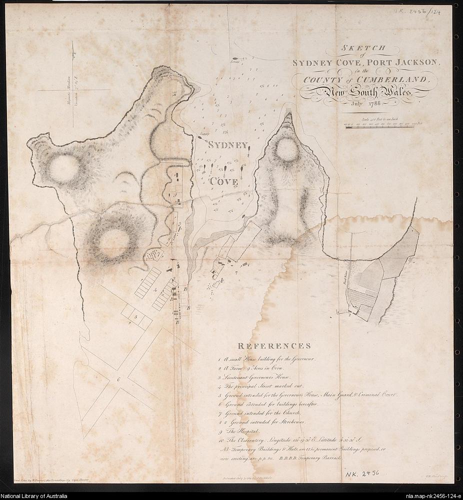
[media]The first survey of the shoreline of Sydney Harbour began two days of the arrival of the First Fleet in Port Jackson. Captain John Hunter and Lieutenant William Bradley set out between 28 January and 6 February 1788 and surveyed the area from the Heads to Homebush Bay. Neither Hunter nor Bradley recorded how they carried out the survey, or the instrumentation they used – Hunter said he made as good a survey as circumstances permitted. [1] He and Bradley did write about landing to take sightings, and Bradley mentions measuring 'another' baseline. [2]
[media]The 1866 Royal Commission of Inquiry into the Condition of the Harbour of Port Jackson provides some insight into their possible methods, describing the Hunter-Bradley survey as a compass survey. This indicates Hunter and Bradley worked without theodolites. [3] They probably used a compass to fix their position, perhaps with a horizontal sextant for measuring directions and bearings, and some means of measuring a few baselines. Depths were obtained with lead lines and plotted to the nearest fathom (1.83 metres).
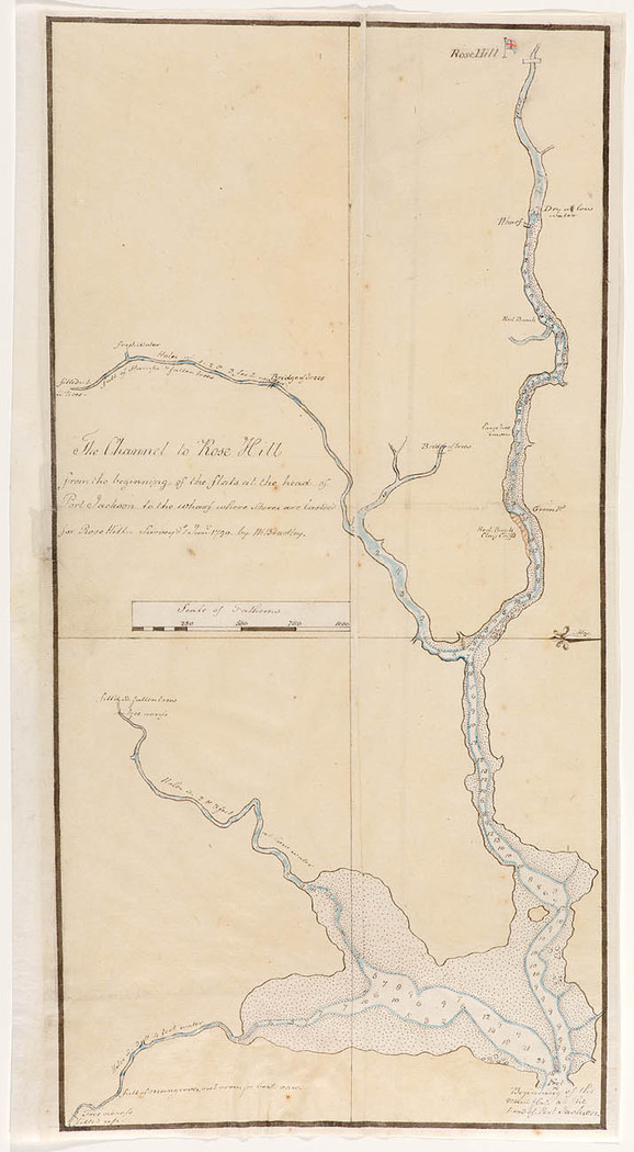
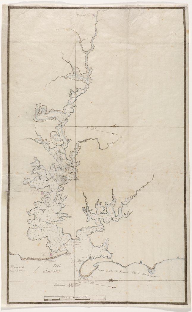
Bradley extended the survey from Homebush Bay to Parramatta in a survey he dated as 1 January 1790. [4] In this more shallow area, he plotted depths to the nearest foot (0.3 metres). The [media]figure compares Hunter and Bradley's chart with the modern shoreline (the mean high water mark) which was supplied to the author by Sydney Ports Corporation. [5] The comparison was made using a Geographic Information System (GIS) to matching up a series of points on the shoreline as closely as possible. [6] One can see that the modern shoreline never quite matches Bradley's survey.
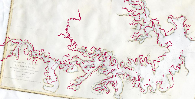
When comparing early charts with modern shorelines, one must bear in mind that the shoreline has been altered in many locations by reclamation, especially in the side bays on the south side of the Harbour. The figure, constructed by Murray in 2003, shows the changes that have occurred from Garden Island to Rozelle Bay around Hen and Chicken Bay and the major changes around Homebush Bay. [7]
John Septimus Roe
Louis de Freycinet[media] made some additions to the charts of Hunter and Bradley in 1802 [8] but John Septimus Roe carried out the next full survey of the Harbour in 1822. [9] The instrumentation available to Roe was far superior to that available to Hunter and Bradley, and included theodolites. Roe also had the advantage of extra time, taking three months to complete his survey and produce the initial chart, whereas Hunter and Bradley's survey lasted just nine days. [10] However, Roe obtained depths using lead line and his sounding densities are far less than would be required in a modern survey.
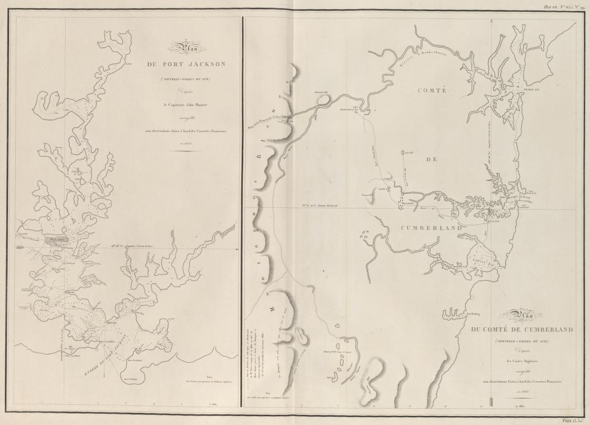
Roe's chart [media]covered the area from the Heads to Parramatta but no soundings were shown west of the Rhodes Peninsula. In his chart, the shaded parts of the shoreline are those resurveyed by Roe. The unshaded portions were copied by Roe from the charts of Hunter and Bradley, and of de Freycinet.
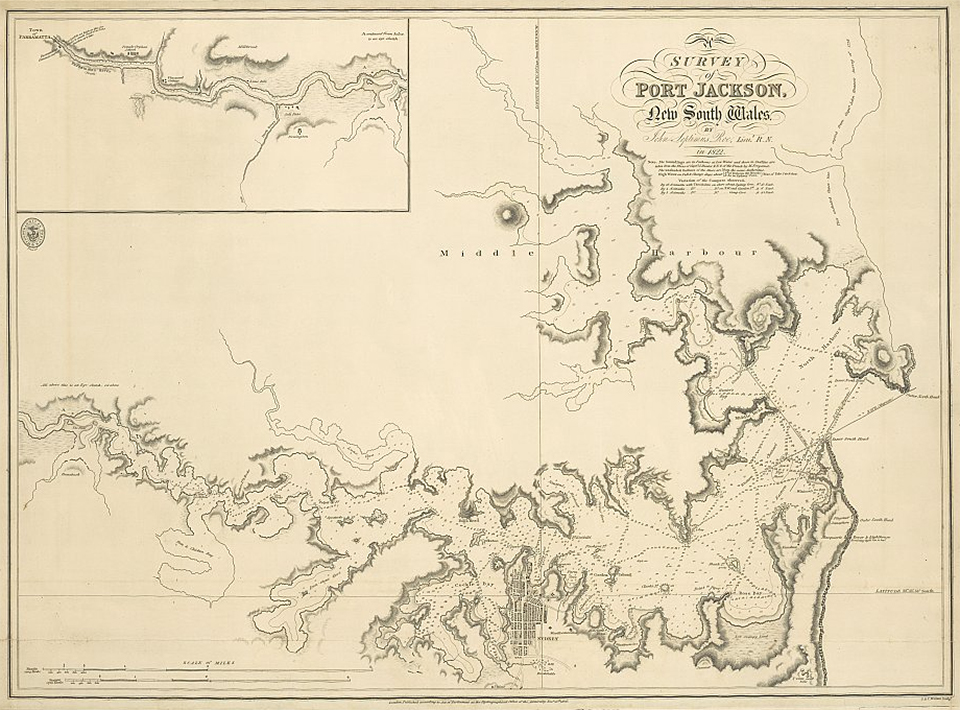
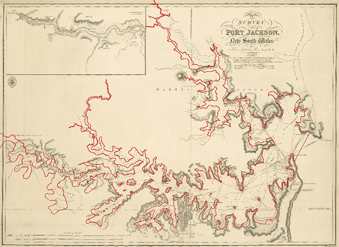
[media]Except for Sydney Cove and Woolloomooloo Bay, reclamation had little effect on the Harbour before 1835. A comparison of Roe's chart with the modern shoreline, in a GIS, shows the match is quite good in the eastern part of the Harbour but goes astray west of Hunters Hill and Cockatoo Island and in Middle Harbour. The match is also weaker in the sections of the Harbour where Hunter and Bradley's chart was used. It appears errors accumulated as the survey party moved away from the main part of the Harbour.
Henry Mangles Denham
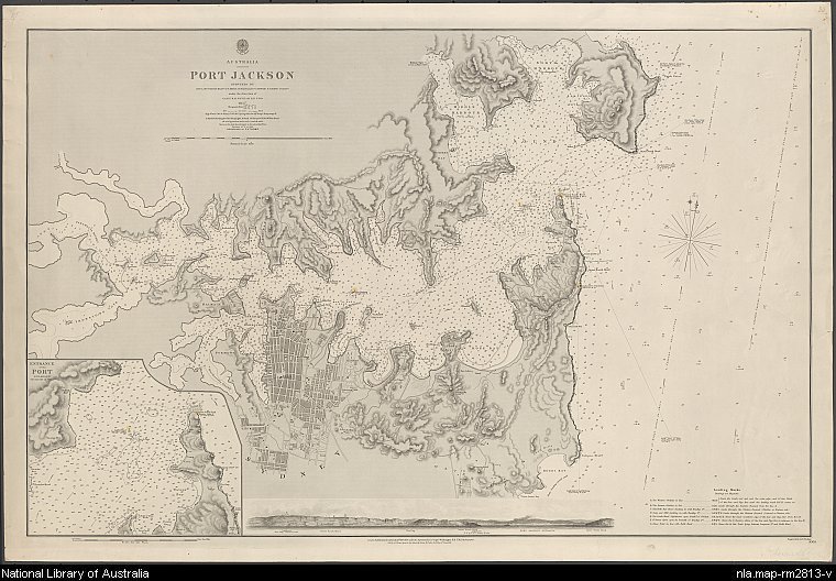
[media]Leaving aside a rather crude survey performed under the command of Hyacinthe de Bougainville in 1828, [11] the next major survey was carried out under the command of Henry Mangles Denham in 1857. [12] The sounding densities of this survey approached those appropriate for a modern chart. The area covered was from 1.5 miles (2.4 kilometres) seawards of the Heads, west to Five Dock Bay, including Lane Cove River and Middle Harbour. However sounding densities were relatively sparse west of Cockatoo Island where a new dry dock, Fitzroy Dry Dock, was opened in late 1857. [13] [media]As with Roe's survey, depths were obtained with lead line and positions by theodolite fixes. A long baseline, 2780 feet long (847.34 metres), was measured out at Rose Bay from which a triangulation scheme was set up to cover all the Harbour as far west as Cockatoo Island. [14] Check baselines were set up at Manly Beach, Darling Point and South Head. The survey and initial chart production took approximately two months. Despite all the care taken in this survey, there are still discrepancies between its shoreline and the modern one, especially west of Darling Harbour. Garden Island was still separate from the mainland and would remain so until World War II.
Pullen and Gubbins
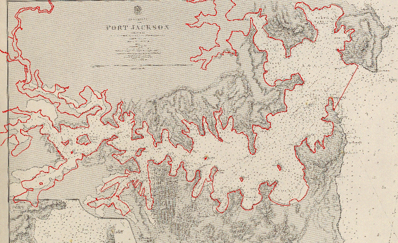
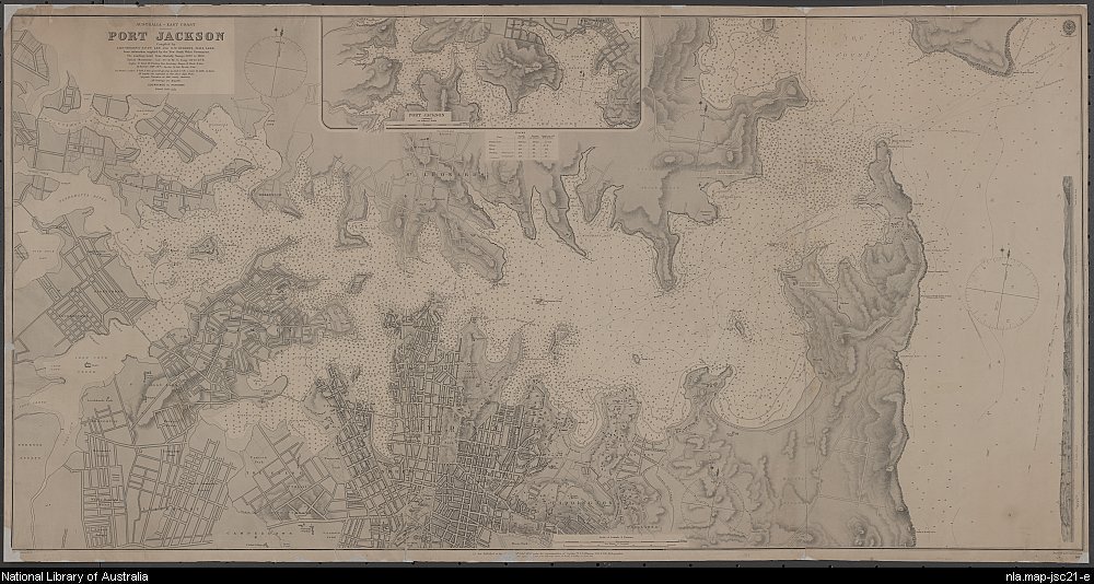
[media]Towards the end of the nineteenth century, lieutenants TF Pullen and GW Gubbins of HMS Lark compiled the latest information available from the New South Wales Government, which was mostly derived from British Admiralty soundings obtained from 1857 to 1888. [15] Sounding densities were even greater than those in Denham's chart. Again the area covered was from outside the Heads and west to Five Dock Bay, including Lane Cove River and Middle Harbour. The [media]shoreline in Pullen and Gubbins' chart more closely conforms to modern charts.
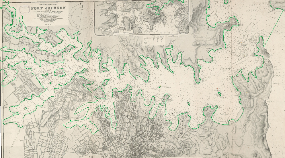
The reasons for the improvement of Pullen's and Gubbins' chart over Denham's are not obvious, but what is apparent the improvement of surveying accuracy over the course of the eighteenth and nineteenth centuries.
Further reading
Phil Mulhearn, 'The Eighteenth and Nineteenth Century Charting of Sydney Harbour/Port Jackson, e-Perimetron.org, vol 9, no 2, 2014, pp. 66–77, http://www.e-perimetron.org/Vol_9_2/Mulhearn.pdf, accessed 10 September 2014
Notes
[1] John Hunter, An historical journal of the transactions at Port Jackson and Norfolk Island with the discoveries which have been made in New South Wales and in the southern ocean since the publication of Phillip's voyage, compiled from the official papers, including the journals of Governors Phillip and King and of Lieut. Ball, and the voyages from the first sailing of the Sirius in 1787, to the return of that ship's company to England in 1792, Libraries Board of South Australia, Adelaide, 1968
[2] William Bradley, A Voyage to New South Wales, the Journal of Lieutenant William Bradley RN of HMS Sirius, 1786–1792, Trustees of the Public Library of New South Wales in association with Ure Smith, Sydney, 1969. In surveying, an accurate baseline is first set out. From this base, angles to other points are measured and a series of triangles set up to cover the area of interest. Distances between points can then be calculated by trigonometry.
[3] New South Wales Legislative Assembly, Report of the Commission to Inquire into the Condition of the Harbour of Port Jackson, New South Wales Legislative Assembly Votes and Proceedings, 1866, vol 2, pp 1–105
[4] The Channel to Rose Hill, Chart 11 in William Bradley, A Voyage to New South Wales, the Journal of Lieutenant William Bradley RN of HMS Sirius, 1786–1792, Trustees of the Public Library of New South Wales in association with Ure Smith, Sydney, 1969
[5] Chart 6 in William Bradley, A Voyage to New South Wales, the Journal of Lieutenant William Bradley RN of HMS Sirius, 1786–1792, Trustees of the Public Library of New South Wales in association with Ure Smith, Sydney, 1969; also John Hunter, Plan of Port Jackson, New South Wales: Lat. 33? 50' S. Long. 151?.25' fr. Greenwich variation of the compass 7?.54' E. 178, J Stockdale, London, 1789; National Library of Australia, MAP NK 2456/125, http://nla.gov.au/nla.map-nk2456-125, accessed 5 December 2013
[6] The method used is described in more detail in Phil Mulhearn, 'The Eighteenth and Nineteenth Century Charting of Sydney Harbour / Port Jackson, e-Perimetron.org, vol 9, no 2, 2014, pp 66–77, http://www.e-perimetron.org/Vol_9_2/Mulhearn.pdf, accessed 10 September 2014. Note that the matching points used were not quite the same as used in this article
[7] O Murray, 'A history of reclamation in Sydney Harbour: A Digital Representation of reclamations in time 1788 – 2002', PhD thesis, School of Geosciences, University of Sydney, Sydney, 2003; also Figure 10 of GF Birch, O Murray, I Johnson and A Wilson, 'Reclamation in Sydney Estuary, 1788–2002', Australian Geographer, vol 40, no 3, 2009, pp 347–368
[8] Plan du Port Jackson (Nouvelle-Galles du Sud) d'apres le Capitaine John Hunter assujetti aux observations faites a bord des corvettes Francaises en 1802; Plan du comte de Cumberland (Nouvelle-Galles du Sud) d'apres les cartes Anglaises assujetti aux observations faites a bord des corvettes Francaises en 1802 in Louis de Freycinet, Voyage de Decouvertes aux Terres Australes, Partie Navigation et Geographie, Paris, 1812; National Library of Australia, MAP RaA 2, Part 31, http://nla.gov.au/nla.map-raa2-s31, accessed 10 September 2014
[9] Survey of Port Jackson, New South Wales, in Phillip Parker King, Charts of the Coast of Australia [cartographic material], Hydrographic Office, London, 1824–1826; National Library of Australia, MAP RaA 5, Part 9, http://nla.gov.au/nla.map-raa5-s9, accessed 5 December 2013
[10] MC Hordern, King of the Australian Coast: The Work of Phillip Parker King in the Mermaid and Bathurst 1817–1822, Melbourne University Press at the Miegunyah Press, Carlton, 1997
[11] Plate 52 from Journal de la navigation autour du globe de la fregate la Thetis et de la corvette l'Esperance pendant les annees 1824, 1825 et 1826 /Publie par ... M. le Baron de Bougainville in Plan du Port Jackson [cartographic material] : leve a bord de la fregate la Thetis commandee par de M. le Baron de Bougainville Capitaine de vaisseau, Chef de lExpedition / par MM. La Pierre et Jeanneret, Officers de la Marine, Arthus Bertrand, Paris, 1837; National Library of Australia, MAP T 982, http://nla.gov.au/nla.map-t982, accessed 5 December 2013
[12] Australia, Port Jackson [cartographic material], surveyed by Lieut J Hutchison, Messrs JW Smith & E Wilds, E Howard and F Hixon; under the direction of Captn HM Denham RNFRS 1857; engraved by J and C Walker, Hydrographic Department, London, 1859; National Library of Australia, MAP British Admiralty Special Map Col/33, http://nla.gov.au/nla.map-rm2813, accessed 10 September 2014
[13] Denham's ship HMS Herald was the first ship to use the dock.
[14] Andrew David, The Voyage of HMS Herald to Australia and the South-west Pacific 1852–1861 Under the Command of Captain Henry Mangles Denham, Melbourne University Press at The Miegunyah Press, Carlton, 1995
[15] Hydrographic Department, Australia – East coast, Port Jackson, compiled by Lieutenants TF Pullen and GW Gubbins, HMS Lark, from information supplied by the New South Wales Government, engraved by Davies and Company, British Admiralty, 5 February, 1890 under the Superintendence of Captain WJL Wharton, RN, FRS Hydrographer; National Library of Australia, MAP JOHNSTON SPECIAL COL./21, http://nla.gov.au/nla.map-jsc21, accessed 5 December 2013
.