
The Dictionary of Sydney was archived in 2021.
Early Hydrographers of Sydney

Citation
Persistent URL for this entry
To cite this entry in text
To cite this entry in a Wikipedia footnote citation
To cite this entry as a Wikipedia External link
Sounding the Harbour
From the arrival of the First Fleet in January 1788 up to the present day, water depths within Sydney Harbour have been surveyed to improve maps for safer navigation. As roads were limited, water transport was often an easier and faster means of travelling and transporting goods.
Throughout the eighteenth and nineteenth centuries, these surveys were carried out under the direction of the Royal Navy, mostly by navy officers with the lowly rank of lieutenant, many of whom went on to have eminent careers.
First surveys
[media]The main early surveyors were lieutenants William Dawes and William Bradley and Captain John Hunter. [1] Dawes accompanied the First Fleet as an astronomer and set up the first observatory at present day Dawes Point. Bradley was the first lieutenant on the HMS Sirius, and Bradleys Head is named after him. He went on to have an outstanding naval career and retired with the rank of rear admiral. He later lost this rank after being found guilty of postal fraud, although there was evidence that he was mentally ill at the time. [2]
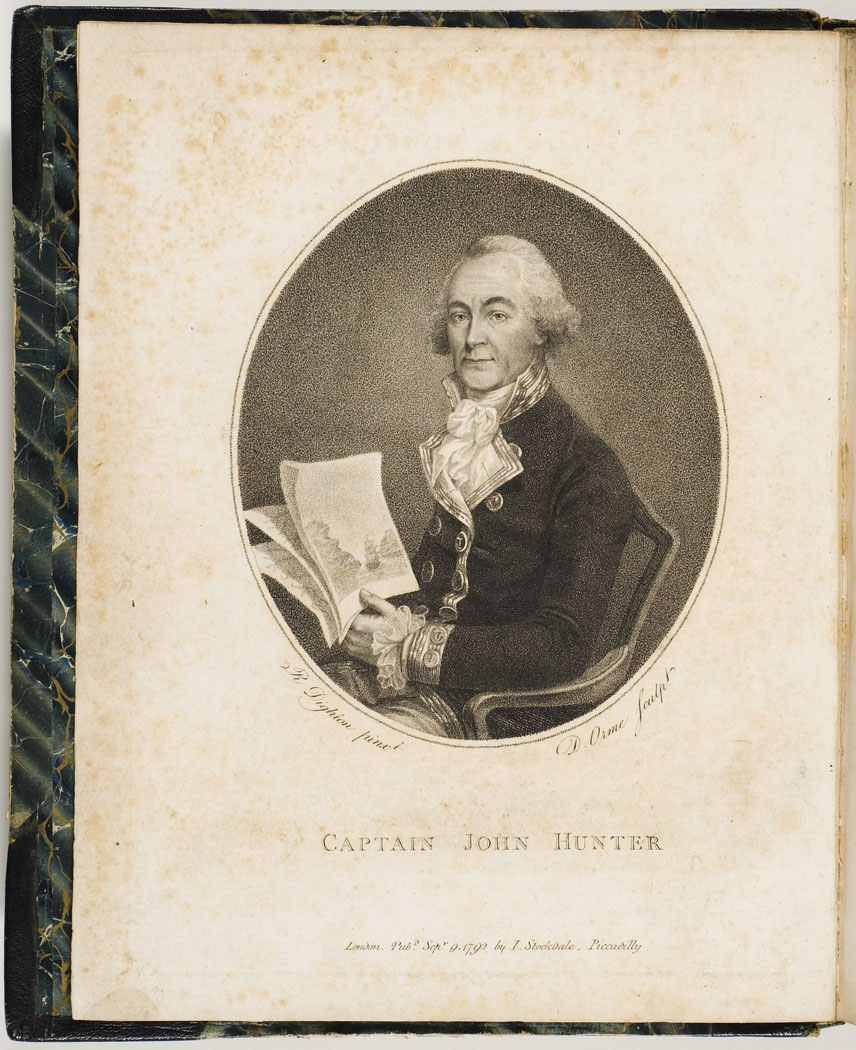
Hunter was the most senior naval officer under Governor Arthur Phillip on the First Fleet and he became the second governor of the colony of New South Wales from 1795 to 1800. His performance as governor was not highly regarded at first by the British Government, but they reassessed this in the light of subsequent problems under later governors. He eventually rose to be a vice-admiral, the same rank as today's Australian Chief of Navy. [3] His name is commemorated in such places as Hunters Hill and the Hunter River.
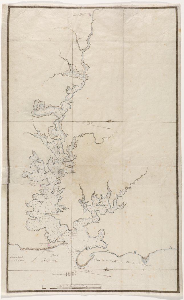
Hunter's [media]main task on arriving in Sydney was the surveying of the local rivers and harbours. By 6 February 1788, Bradley and Hunter had surveyed Port Jackson from the Heads to 'The Flats' (present day Homebush Bay), plus Middle Harbour and the lower Lane Cove River. [4] In the following year, Bradley surveyed Parramatta River from The Flats to Rose Hill (present day Parramatta). [5] He also did a detailed survey in 1789 of a cove on the north side of the Harbour (present day Mosman Bay), where the Sirius was refitted. [6] A sketch map by Dawes, [7] with soundings taken by Hunter, has a different set of soundings from those in Bradley's map of March 1788. [8] Bradley undertook various other short surveys and recorded various observations of the local Aboriginal people. He, with Hunter, also surveyed Norfolk Island after the Sirius was wrecked there.
Deepening understanding in the early nineteenth century
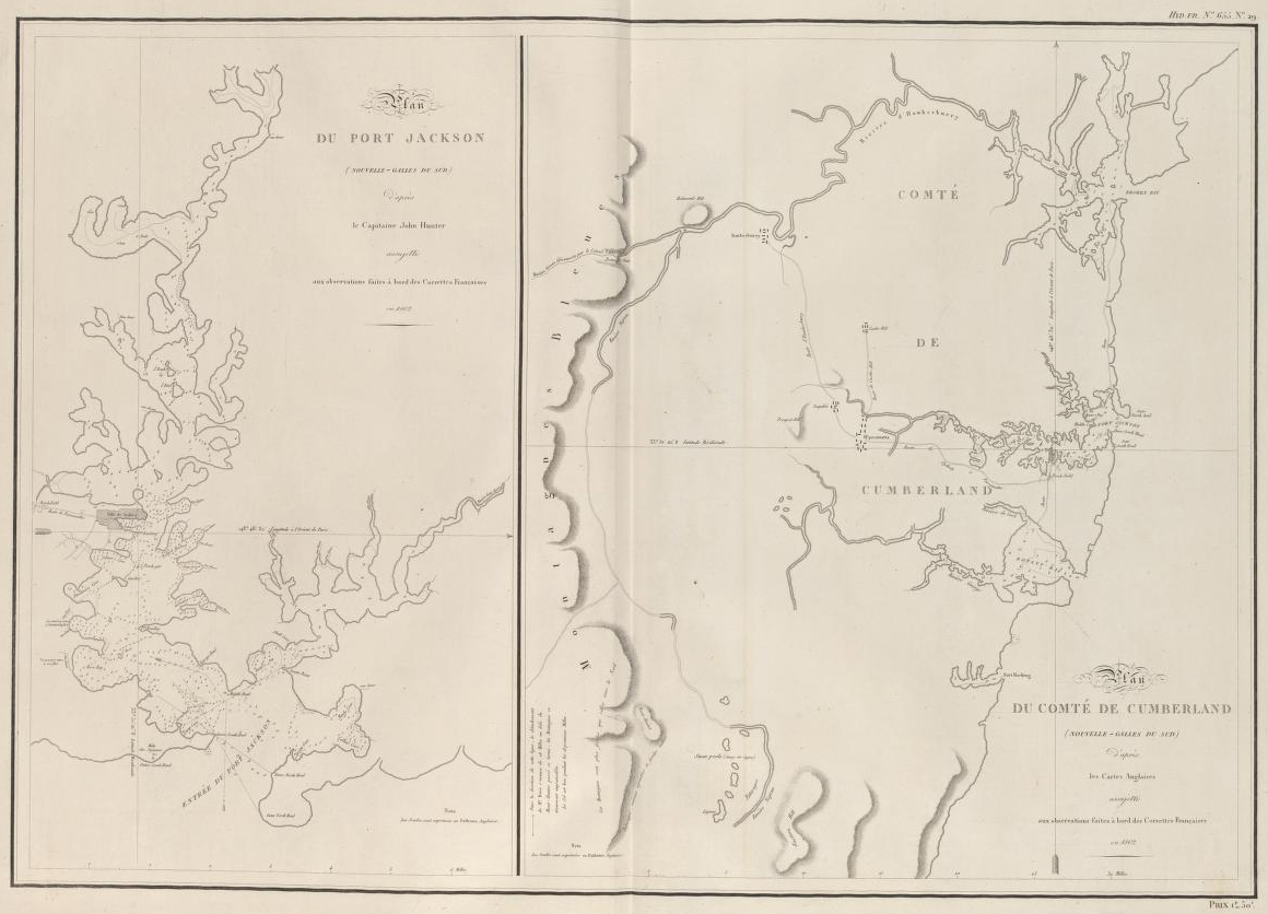
[media]Subsequent surveys in the first half of the nineteenth century added to Hunter and Bradley's work, but sounding densities were quite sparse compared to those required in modern surveys for safety of navigation. During Nicolas Baudin's scientific expedition to complete the French survey of Australia's coast, Baudin's colleague Louis de Freycinet took additional soundings for Port Jackson in 1802 and added these to those of Bradley and Hunter in a fresh chart. [9]
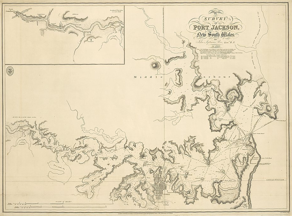
The [media]next overall survey of Sydney Harbour was carried out in 1822 by Lieutenant John Septimus Roe, who was trained as a hydrographer. [10] He is more associated with Western Australia than New South Wales, since most of his surveying work was around Australia's northern and western coastlines, under Phillip Parker King. [11] He later became the first Surveyor-General of Western Australia and was a leading figure in its early years. He undertook sixteen expeditions within Western Australia and his extensive natural history collections were the foundation of the Perth Museum. [12]
[media]In 1825, Hyacinthe de Bougainville, in the course of an around-the-world voyage, visited Sydney for three months. While there, his men carried out a survey of Sydney Harbour, but the shoreline in their map is crude compared to those depicted in the maps of Roe and Hunter. [13] De Bougainville had taken part in Baudin's earlier French expedition, but his own voyage was more for purposes of trade and diplomacy than science or exploration. He rose to become a rear admiral and a member of the French Admiralty Board. [14]

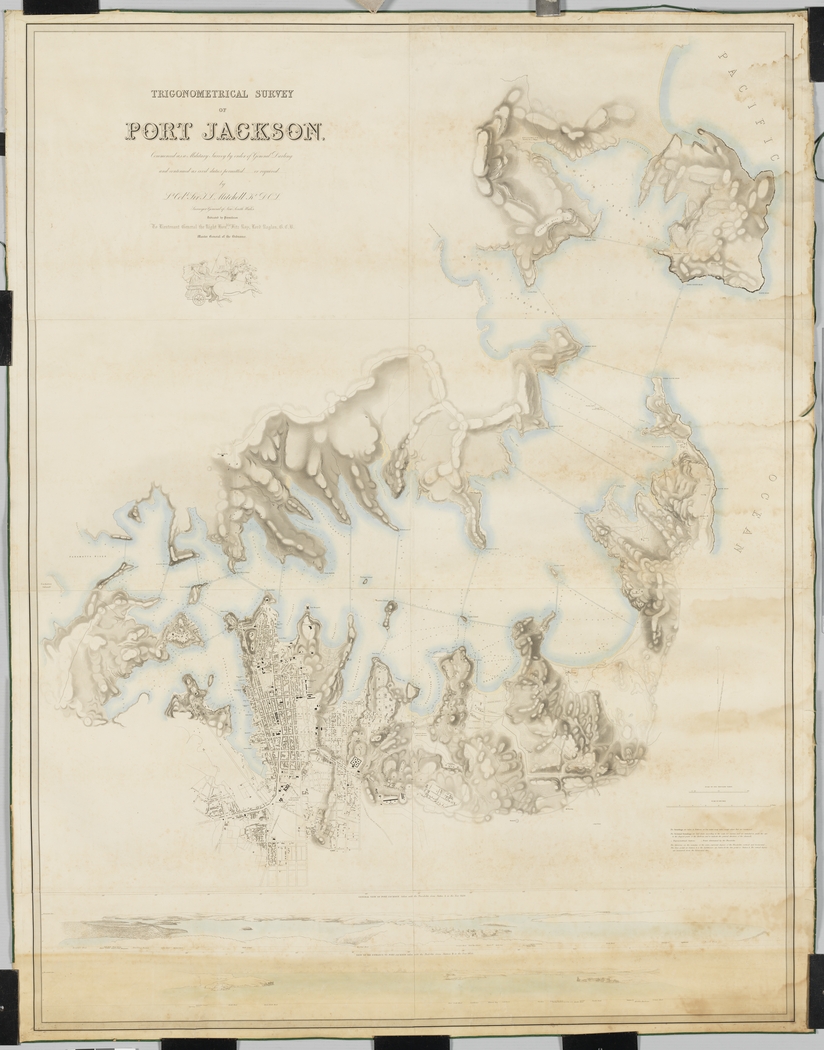
[media]An 1853 map of the Trigonometrical Survey of Port Jackson, undertaken under the direction of Surveyor-General Thomas Livingstone Mitchell, shows soundings within Port Jackson and a number of cross-sections of the Harbour, but sounding densities were still sparse by modern standards. [15]
Naval command in the later nineteenth century
With the discovery of gold in the 1850s and the need to protect the gold shipments, the Royal Navy began to take a greater interest in New South Wales. In 1859 it established a new Australian Station, a naval command separate from the East Indies Station, to be responsible for waters around Australia. It was initially under the command of a commodore but was upgraded in 1884 to be commanded by a rear admiral. [16] This greater naval involvement may explain the significant improvement in hydrographic surveys which occurred about this time.
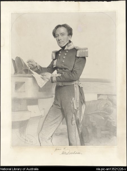
Surveying [media]entered a new era with the thorough and detailed survey work undertaken under the direction of Captain Henry Mangles Denham. Denham already had an outstanding record as a hydrographer before his 1857 survey of Sydney Harbour. [media]He had been made a Fellow of the Royal Society in 1839 for services to hydrography. As Captain of HMS Herald surveyed not only Sydney Harbour, but much of the Australian coast and of the south-west Pacific, on a voyage that lasted from 1852 to 1861. Previously he had been involved in surveys off the coast of France, parts of England and Ireland, and West Africa. From 1864 to 1866 he was Commander-in Chief, Pacific Station, for the Royal Navy and received a knighthood in 1866. He retired as a vice admiral in 1871.
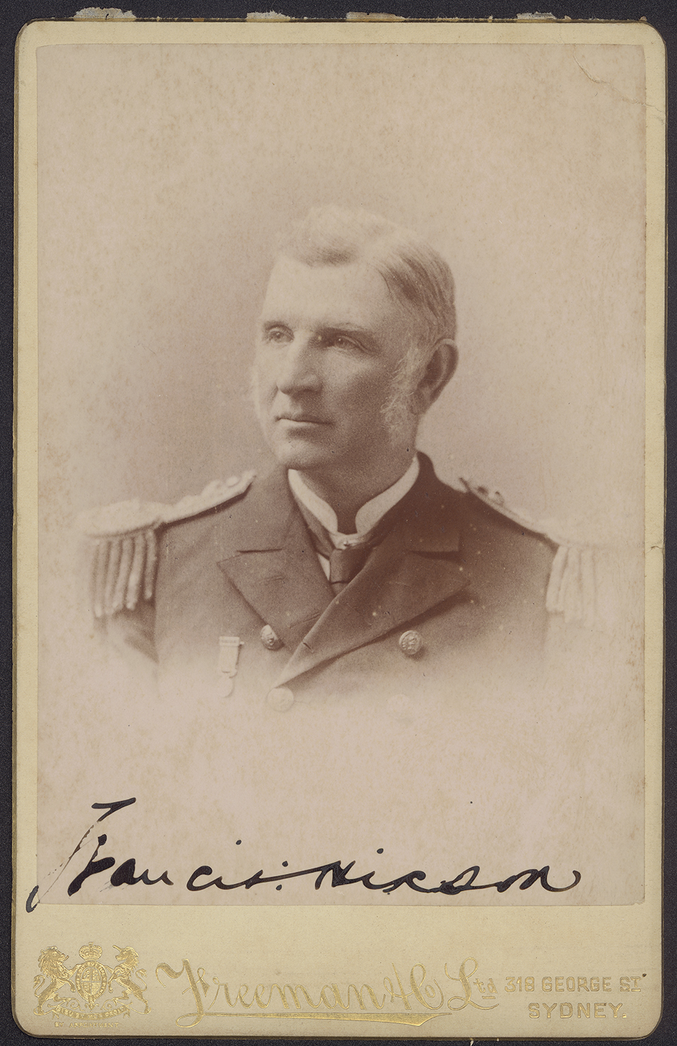
[media]The people who did the actual surveying under Denham's command were John Hutchison, Joseph W Smith, Edward Wilds, Frederick Howard and Francis Hixon. Hutchison later became head of the South Australian survey, first assisted, then succeeded, by Howard.. While Smith and Wilds pursued their careers overseas, Hixon went on to make major contributions in New South Wales. He became Superintendent of Pilots, Lighthouses and Harbours, organised the Volunteer Naval Brigade which was sent to China at the time of the Boxer Rebellion, served as a commissioner of the Marine Board of New South Wales (the forerunner of the present day Sydney Ports Corporation and maritime section of New South Wales’ Roads and Maritime Services), was a member of the Fisheries Commission which helped establish the New South Wales fishing industry and helped design the New South Wales state flag. [17]
The 1866 Royal Commission Appointed to Inquire Into the Condition of the Harbour of Port Jackson said of Hunter and Bradley's survey that it appeared 'to merely be a compass reconnaissance, and does not, we think, contain such evidence of its accuracy as would lead us to place much reliance on it for comparison'. [18] The commissioners were concerned with shallowing of the Harbour by sedimentation and compared surveys. They thought Roe's survey was carefully executed but that its scale was too small, and the fact that he reduced soundings to the nearest fathom (1.83 metres) made it of no use for their purposes. [19] The commissioners ignored the surveys of de Bougainville and Mitchell.
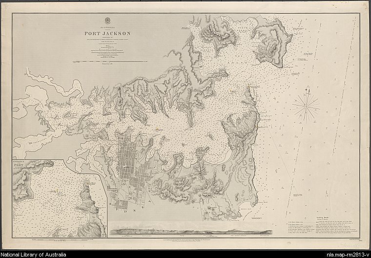
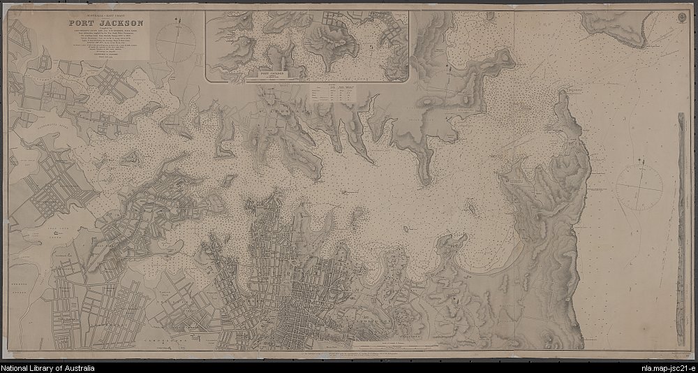
[media]The final work of the 19th century was that of lieutenants TF Pullen and GW Gubbins of HMS Lark, who compiled the latest information available from the New South Wales Government, which consisted mostly of British Admiralty soundings taken from 1857 to 1888. [20] In 1890 the Admiralty published a revised chart containing the information compiled by Pullen and Gubbins, which continued to be revised until 1945.
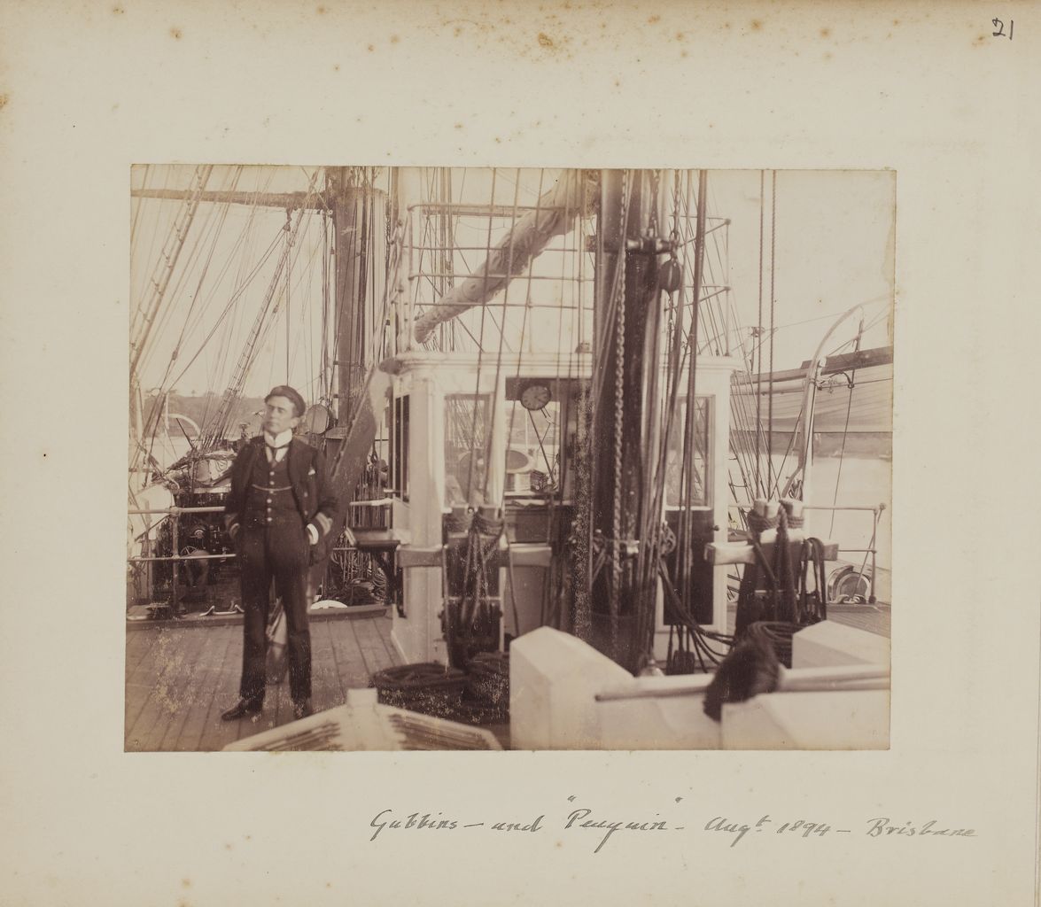
[media]Not much is known of Gubbins; he was employed on an 1894 Admiralty survey of Jervis Bay and he is seen in a couple of photographs on board the survey ship HMS Penguin. [21] Pullen was commander of the Lark from 1884 to 1888, with the principle task of surveying New Guinea. He later was responsible for surveys of both the east and west African coasts, with a particular emphasis on defining boundaries between European colonies. Together with South African astronomer WH Finlay, he made the first telegraphic determinations of longitude along the west coast of Africa. [22] He died of malaria while on survey in the west African coast. [23]
[media]In 1901 the Sydney Harbour Trust was formed with hydrographic surveying of the Harbour as part of its responsibility. This, together with the regularly updated Admiralty charts, marked a new era in charting the Harbour for safety of navigation. The painstaking work of carrying out hydrographic surveys may not seem very glamorous, however, it is very important for safety of shipping. It is striking how many of the early hydrographers went on to have careers of great importance in the public eye.
References
W Bradley, A Voyage to New South Wales, The Journal of Lieutenant William Bradley RN of HMS Sirius, 1786–1792, Trustees of the Public Library of New South Wales in association with Ure Smith, Sydney, 1969
Andrew David, The Voyage of HMS Herald to Australia and the South-West Pacific 1852–1861 Under the Command of Captain Henry Mangles Denham, The Miegunyah Press (Melbourne University Press), Carlton South, Victoria, 1995
Hyacinthe de Bougainville, Journal de la Navigation Autour Du Globe de la Frégate Thétis et de la Corvette L'Espérance, Arthus Bertrand, Paris, 1837
Hyacinthe de Bougainville, The Governor's Noble Guest – Hyacinthe de Bougainville's Account of Port Jackson 1825, translated and edited by Marc Serge Rivière, The Miegunyah Press (Melbourne University Press), Carlton South, Victoria, 1999
J Hunter, An historical journal of the transactions at Port Jackson and Norfolk Island with the discoveries which have been made in New South Wales and in the southern ocean since the publication of Phillip's voyage, compiled from the official papers, including the journals of Governors Phillip and King and of Lieut Ball, and the voyages from the first sailing of the Sirius in 1787, to the return of that ship's company to England in 1792, Libraries Board of South Australia, Adelaide, 1968
Pamela Mawbey, 'Baron Hyacinthe Bougainville: L'amoure's Ups and Downs at the Sydney Botanic Gardens', 2009, Royal Botanic Gardens website, http://www.rbgsyd.nsw.gov.au/welcome/quick_links/our_history/bougainville, accessed 5 December 2013
Phil Mulhearn, 'The 18th and 19th Century Charting of Sydney Harbour / Port Jackson', e-Perimetron.org, vol 9, n 2, 2014, pp 66–77, http://www. e-perimetron.org/Vol_9_2/Mulhearn.pdf, accessed 10 September 2014
Maura O'Connor, Terry Birtles, Martin Woods and John Clark, Australia in Maps: Great Maps in Australia's History from the National Library's Collection, National Library of Australia, Canberra, 2007
Francois Péron and Louis de Freycinet, Voyage de decouvertes aux terres australes. Partie navigation et géeographie, execute sur les corvettes le Géographe, le Naturaliste et la goëlette Casuarina, pendant les années 1800, 1801, 1802, 1803 et 1804, sur le commandment du Capitaine de vaisseau N Baudin. Navigation et Géographie. Imprimerier Impériale, Paris, 1807-1816
Notes
[1] Phyllis Mander-Jones, 'Dawes, William (1762–1836)', Australian Dictionary of Biography, National Centre of Biography, Australian National University, http://adb.anu.edu.au/biography/dawes-william-1968/text2377, accessed 27 August 2014
[2] Janet D Hine, ‘Bradley, William (1757–1833)’, Australian Dictionary of Biography, National Centre of Biography, Australian National University, http://adb.anu.edu.au/biography/bradley-william-1820/text2085, accessed 21 November 2013
[3] JJ Auchmuty, 'Hunter, John (1737–1821)', Australian Dictionary of Biography, National Centre of Biography, Australian National University, http://adb.anu.edu.au/biography/hunter-john-2213/text2873, accessed 27 August 2014
[4] Chart 6 in W Bradley, A Voyage to New South Wales, the Journal of Lieutenant William Bradley RN of HMS Sirius, 1786–1792, Trustees of the Public Library of New South Wales in association with Ure Smith, Sydney, 1969; see also John Hunter, Plan of Port Jackson New South Wales [cartographic material] : Lat. 33? 50' S. Long. 151?.25' fr. Greenwich variation of the compass 7?.54' E. 1788 / by Capt John Hunter; J Reid & W Harrison sc, National Library of Australia, MAP NK 2456/125, http://nla.gov.au/nla.map-nk2456-125, accessed 5 December 2013
[5] The Channel to Rose Hill, chart 11 in W Bradley, A Voyage to New South Wales, the Journal of Lieutenant William Bradley RN of HMS Sirius, 1786–1792, Trustees of the Public Library of New South Wales in association with Ure Smith, Sydney, 1969; see also Flats at the head of Port Jackson and channel up to Rose Hill, ZMT4 140/1792/1, digital order number a127082, in William Bradley – charts from his journal 'A Voyage to New South Wales', 1802+, State Library of New South Wales, http://acms.sl.nsw.gov.au/item/itemdetailpaged.aspx?itemid=404927#, accessed 3 September 2014
[6] Cove on the North side of Port Jackson where the Sirius was refitted; chart 10 in W Bradley, A Voyage to New South Wales, The Journal of Lieutenant William Bradley RN of HMS Sirius 1786–1792, Trustees of the Public Library of New South Wales in association with Ure Smith, Sydney, 1969, see also Cove on the northern side of Port Jackson where the Sirius was refilled, 1789, digital order number a138501, in William Bradley – charts from his journal 'A Voyage to New South Wales', 1802+, State Library of New South Wales, http://acms.sl.nsw.gov.au/item/itemdetailpaged.aspx?itemid=404927#, (a copy by George Raper is not quite the same as that in Bradley’s Journal, Carreening Cove No. side Port Jackson where HMS Sirius refitted and repair'd 1789 [cartographic material], 1789, National Library of Australia, MAP RM 3459 Held at MS 9433, http://nla.gov.au/nla.map-rm3459, accessed 3 September 2014
[7] Thomas Medland, Sketch of Sydney Cove, Port Jackson in the County of Cumberland New South Wales July 1788 [cartographic material] 1789, National Library of Australia, MAP NK 2456/124, http://nla.gov.au/nla.map-nk2456-124, accessed 3 September 2014
[8] Sydney Cove Port Jackson, chart 7 in W Bradley, A Voyage to New South Wales, The Journal of Lieutenant William Bradley RN of HMS Sirius 1786–1792, Trustees of the Public Library of New South Wales in association with Ure Smith, Sydney, 1969; see also State Library of New South Wales website, 'William Bradley (1757?–1833)', http://www.sl.nsw.gov.au/discover_collections/history_nation/terra_australis/charts_maps/bradley_charts/, accessed 27 August 2014
[9] Plan du Port Jackson (Nouvelle-Galles du Sud) d'apres le Capitaine John Hunter assujetti aux observations faites a bord des corvettes Francaises en 1802; Plan du comte de Cumberland (Nouvelle-Galles du Sud) d'apres les cartes Anglaises assujetti aux observations faites a bord des corvettes Francaises en 1802, from Louis de Freycinet, Voyage de decouvertes aux terres australes: execute par ordre de S.M.L’Empereur et Roi sur les corvettes le Géographe, le Naturaliste, et la goëlette Casuarina, pendant les années 1800, 1801, 1802, 1803 et 1804, [Tome 3]. Partie navigation et geographie. Atlas, Paris, 1812, National Library of Australia, MAP RaA 2, part 31, http://nla.gov.au/nla.map-raa2-s31, accessed 27 August 2014
[10] John Septimus Roe, Survey of Port Jackson New South Wales, in Phillip Parker King, charts of the coast of Australia, National Library of Australia, 1824–1826, National Library of Australia, MAP RaA 5, part 9, http://nla.gov.au/nla.map-raa5-s9 accessed 21 November 2013
[11] Anonymous 'King, Phillip Parker (1791–1856)', Australian Dictionary of Biography, National Centre of Biography, Australian National University, http://adb.anu.edu.au/biography/king-phillip-parker-2310/text2993, accessed 5 December 2013
[12] Malcolm Uren, 'Roe, John Septimus (1797–1878)', Australian Dictionary of Biography, National Centre of Biography, Australian National University, http://adb.anu.edu.au/biography/roe-john-septimus-2600/text3575, published in hardcopy 1967, accessed 31 August 2014
[13] H de Bougainville, Journal de la navigation autour du globe de la fregate la Thetis et de la corvette l'Esperance pendant les annees 1824, 1825 et 1826, Arthus Bertrand, Paris, 1837, Plate 52; Plan du Port Jackson [cartographic material]: leve a bord de la fregate la Thetis commandee par de M. le Baron de Bougainville Capitaine de vaisseau, Chef de lExpedition / par MM. La Pierre et Jeanneret, Officers de la Marine, also at National Library of Australia, 1837, MAP T 982, http://nla.gov.au/nla.map-t982, accessed on 21 November 2013
[14] Etienne Taillemite, 'Un marin polytechnicien autour du monde: Hyacinthe de Bougainville', La Societe des Amis de la Biblioteque de l'Ecole Polytechnique (SABI) Summary Bulletin, 31, August 2002, http://www.sabix.org/bulletin/b31/hyacinthe.html#hyacinthe, accessed 27 August 2014
[15] Trigonometrical survey of Port Jackson: commenced as a military survey by order of General Darling and continued as civil duties permitted or required, by Lt Col Sir TL Mitchell Kt DCL Surveyor General of New South Wales, engraved by JW Lowry, 2000–09, National Library of Australia, MAP RM 1267, http://nla.gov.au/nla.map-rm1267, accessed 27 August 2014
[16] G Andrews, Port Jackson 200, Reed Books, Frenchs Forest, NSW, 1986
[17] Andrew David, The Voyage of HMS Herald to Australia and the South-West Pacific 1852–1861 under the command of Captain Henry Mangles Denham, The Miegunyah Press (Melbourne University Press), Carlton South, Victoria, 1995
[18] New South Wales Parliament, Commission Appointed to Inquire Into the Condition of the Harbour of Port Jackson, Report of the Commission Appointed to Inquire into the Condition of the Harbour of Port Jackson, 1866, vol 2, pp 1-105
[19] For depths less than ten fathoms (18.3 m) soundings were plotted to the nearest quarter fathom, or 0.46 m).
[20] Australia-East Coast, Port Jackson, compiled by Lieutenants TF Pullen and GW Gubbins, HMS Lark, from information supplied by the New South Wales Government, engraved by Davies and Company, 1890, Great Britain, Hydrographic Department, 1890, National Library of Australia, Map Johnston Special Col/21, http://nla.gov.au/nla.map-jsc21, accessed 27 August 2014
[21] 'Lieutenant GW Gubbins aboard the survey vessel HMS Penguin, Brisbane, August 1894’, Hume Photograph Collection, University of Queensland Library website, http://www.library.uq.edu.au/fryer/hume/web/768.html, accessed 5 December 2013
[22] 'Obituary: WH Finlay', Nature, vol 115, 4 April 1925, pp 502–503
[23] 'Obituary: Commander TF Pullen, RN', Proceedings of the Royal Geographical Society and Monthly Record of Geography, vol 11, no 12, December 1889, pp 738–740, http://www.jstor.org/stable/1801098, accessed 27 August 2014