
The Dictionary of Sydney was archived in 2021.
Ryde

Citation
Persistent URL for this entry
To cite this entry in text
To cite this entry in a Wikipedia footnote citation
To cite this entry as a Wikipedia External link
Ryde
[media]Ryde is one of 16 suburbs that form the City of Ryde. The city is approximately 12 kilometres from the centre of Sydney and occupies most of the divide between the Parramatta and Lane Cove rivers. It is bisected from west to east by one of Sydney's busiest roads, Victoria Road. It is crossed north–south by another main road, Lane Cove Road and is skirted on the northwest by the M2 motorway and Epping Road.

The Wallumedegal people and European settlement
At the time of the arrival of Europeans at Sydney Cove in January 1788, the Wallumedegal or Wallumede people were the traditional owners of the area which they called Wallumetta. This clan formed part of the larger Dharug language group.
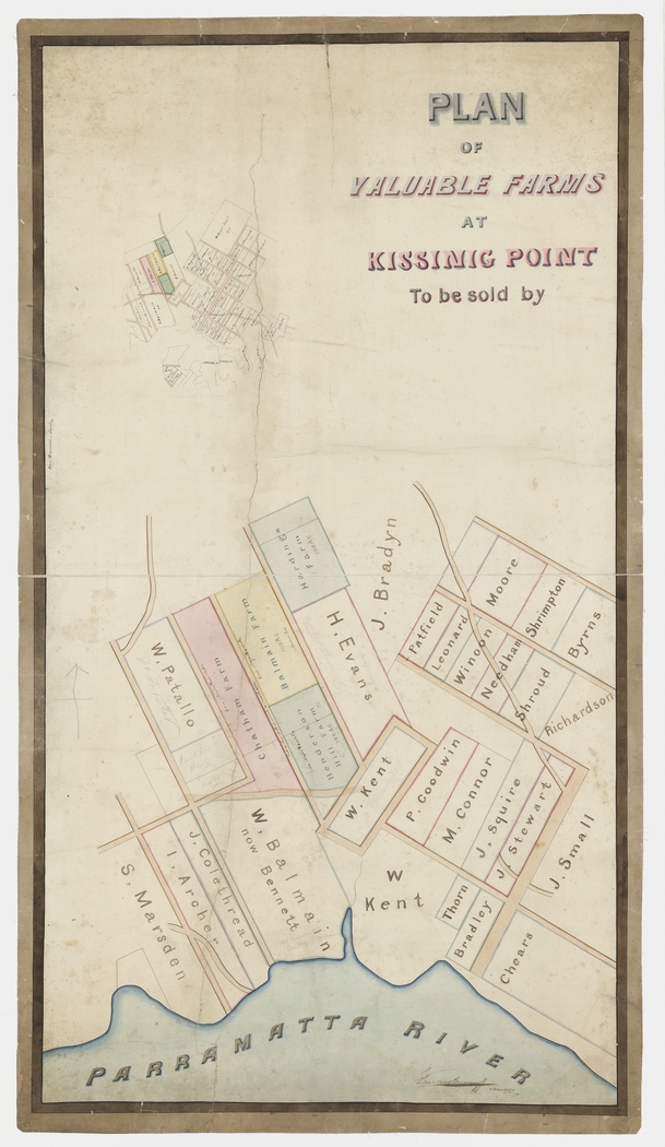
The first grants of land in the local government area of Ryde were in the area now called Melrose Park, to two ex-marines, Isaac Archer and John Colethread, on 3 January 1792. The first grants of land in the modern-day suburb of Ryde were to ten emancipated convicts in February 1792, east of the land granted to the marines. The area was called Eastern Farms or the Eastern Boundary because it was east of Parramatta. Four of these settlers, William Careless, Richard Cheers, John C Morris and James Weavers, were given 30-acre (12-hectare) grants in recognition of their bravery when their convict transport, the Guardian, which left England in September 1789, hit an iceberg off the Cape of Good Hope. While many on board abandoned ship, a small number of convicts, including those named, made a valiant attempt to save the vessel. Eventually, the survivors reached Sydney on the Surprise, a Second Fleet ship.
By 1794 the area was called Kissing Point, a name believed to have originated from the way in which heavily laden boats passing up the Parramatta River bumped or 'kissed' the shallow bottom as they rounded a particular point in the river. In 1798 the district boasted the largest concentration of settlers in the colony. It became an important supplier of fresh foodstuffs to the Sydney markets with fruit, vegetables, poultry, maize and pigs.
James Squire, Bennelong and other Ryde personalities
[media]Early settlers in the area included James Squire who was transported on the Friendship in the First Fleet. By 1798 he was the licensed proprietor of an inn called the Malting Shovel located beside the Parramatta River. At the time of his death in 1822, he owned significant sections of modern-day Tennyson Point and Putney. James Squire was associated with Bennelong, a prominent Aboriginal personality of the area. A Wangal man, Bennelong was taken captive by the British in late 1789. He spent some time in the colonists' company, but eventually returned to traditional Aboriginal life. When Bennelong died at Kissing Point in January 1813, he was buried on Squire's property.

John Small, also a First Fleet convict, [media]was granted land in 1794. He served as district constable for 17 years. While his land holdings amounted to no more than 75 acres (30.3 hectares), his large family of sons and daughters established a network of farms and properties throughout the district. Willandra, built c1845 by James Devlin and his wife Susannah Hughes (John Small's granddaughter) still stands, and has a commanding position at the corner of Church Street and Victoria Road.

James Shepherd, transported in 1791, and his wife Ann Thorn were substantial landholders in the Ryde and Meadowbank areas. Properties with which their family was associated include Addington, The Retreat (which both still stand) and Helenie.
Nineteenth century growth
[media]The establishment of St Anne's Anglican church on a ridge overlooking the river in 1826–27 provided a focal point for the subsequent development of the village of Ryde. It was initially known as the Kissing Point church, and the first resident minister was Reverend George Edward Turner, who took up residence as soon as the parsonage was completed in April 1840. His wife Mary is significant in the history of the area because her birthplace, Ryde, on the Isle of Wight in the United Kingdom, inspired the name given to the area. The earliest reference to 'Ryde' as a locality is on a plan prepared for an auction of land in 1841 titled 'Plan of the village of Ryde, Kissing Point, NSW 1841'.
Subdivisions of surrounding land occurred in the 1840s and 1850s and buildings such as a court house (1863) (with subsequent additions housing a post office and Registry of Births, Deaths and Marriages), Wesleyan Methodist churches (1849, 1870) and the Oddfellows Hall (1869) were built in close proximity to St Anne's.
Not all civic buildings were in this precinct. The police station, reputed to be the oldest police building still in use in New South Wales, was built in 1837–38, fronting the main road from Ryde to Parramatta on land provided by Isaac Shepherd.
The church of St Charles Borromeo was the first Catholic church in Ryde. It was built in 1857 on land that had been donated as early as 1841, fronting the Great North Road. In 1858 a Roman Catholic schoolhouse was opened, offering Catholic families an alternative to the parish school that operated at St Anne's. The present church was built in 1934, but the porch with belfry was the front door of the old church, and much of the original stone was re-used.
The first public school in Ryde was established on the corner of present day Blaxland and Tucker streets in 1868, and was relocated to its present site in 1877.
In the Oddfellows Hall on 2 January 1870 a petition was prepared arguing for local government to be granted to the area. Thus Ryde and its adjoining suburbs were proclaimed a municipality in 1870 and the first elections were held in 1871. In 1894 the Marsfield (later Eastwood) municipality seceded from Ryde municipality, only to rejoin in 1948.
The 1870s witnessed slow development in and around the township of Ryde itself, as old families began to subdivide their estates. The Shepherds, Hattons and Smalls were among the subdividers and members of all three families built new houses on the edge of the township. The impetus to growth in the 1880s was a response to general improvements in communication between the district and the rest of Sydney. This was due to the opening of the first Gladesville bridge in 1881 and of the Strathfield–Hornsby railway line in 1886 which had freight stations at Ryde (now West Ryde), Dundas (now Eastwood) and Field of Mars (now Epping).
Ryde village from the 1880s until the turn of the century centred on Glebe (Victoria Road) and Church streets with just a few shops established in Parkes Street (now Blaxland Road). In the first decade of the twentieth century, Parkes Street slowly emerged as the main commercial street. This was exemplified by the establishment by Ryde council of a new purpose-built town hall in 1903 at the corner of Parkes and Tucker streets. Four years later, a new post office was constructed diagonally opposite, at the corner of Church and Parkes streets.
Transport by river, road and railway
Transport routes have played a significant part in Ryde's character and development. Its southern boundary is the Parramatta River. This has been a means of transport for people and produce, a place where industry developed, including significant shipbuilding activities at Kissing Point (such as Kidman & Mayoh's shipyard and Halvorsen boatshed) and an area for recreation, including swimming baths and rowing. Ryde bridge was opened in 1935. This replaced the old Ryde punt which had begun operation in 1898. It had crossed from Ryde to Rhodes (on the southern bank of the Parramatta River) just below the Meadowbank railway bridge. A second and parallel Ryde bridge was opened in 1988.
The first public wharf to be built in Ryde was completed in 1863. A government grant of £150 was made to construct a road (Belmore Road) from the police watch-house. From about 1866, ferry services started using the wharf to take passengers to and from Sydney or Parramatta. This service continued until 1928. Activity around Ryde wharf declined in the 1880s because of the building of the Gladesville bridge and the Strathfield–Hornsby railway line. By 1898, only ten per cent of passengers travelling out of the area went by river. This decline continued when the tramline was extended from Gladesville bridge to Ryde in June, 1910. It initially terminated at Hatton's Flat, a triangle of land that had been a recreation area for the people of Ryde. By 1914 the line was extended from Ryde post office to the present West Ryde railway station.
The Great North Road, from Sydney to Wisemans Ferry, followed the ridge line through Ryde and its adjoining suburbs. Modern-day Victoria Road follows this route from Gladesville to Ryde, but whereas Victoria Road continues through West Ryde towards Parramatta, the Great North Road turned north at Ryde and followed what is now North Road towards Pennant Hills and thence Newcastle.
Tourism and shopping in Top Ryde
While the spread of the 'centre' from Church Street to Parkes Street (now Blaxland Road) was happening, entrepreneurs foresaw a bright future for tourism at Ryde. Harry Curzon Smith bought 17 acres (7 hectares) on the edge of the village of Ryde at the beginning of 1904. He subdivided the greater portion of this land, but reserved a large block on the corner of Pope Street and Lane Cove Road and around 1909 began building a tourist resort. He gave it the name Hampton Court Tourist Residential. It was to be a five-storey structure with 70 bedrooms, billiard rooms, spacious cellars, a turret tower of two further storeys and a flat promenade roof. Smith also envisaged extensive picnic grounds across Hattons Flat, with the expectation that Hampton Court would be a rendezvous for tourists. However Harry Smith died in June 1913, leaving Hampton Court unfinished.
Smith's vision did eventuate many decades later, even though Hampton Court was demolished. In 1957 the Top Ryde Shopping Centre was established, near the site of Hampton Court. It comprised a department store and 41 shops with parking for about 400 cars, and was a new concept in shopping, based on an American model. It was the first of its kind in the southern hemisphere. Its place as the premier shopping venue was severely affected with construction of centres such as Macquarie Centre, and in 2007 it was demolished and redeveloped.
A civic centre
While the suburb of Ryde is no longer the commercial centre of the Ryde local government area, it is its civic centre, containing the council chambers and offices for the municipality. Council had operated in premises at various locations since its inception, including Church Street and the corner of Blaxland Road and Tucker Street, but in 1964 it built a landmark building at Hattons Flat, the former tram terminus in Devlin Street. A hall and library were added in 1970.
Ryde was also the location for events during the Sydney Olympics – in 2000 the newly-built Ryde Aquatic Leisure Centre was the venue for the water polo events.
References
Gregory Blaxell, The river: Sydney Cove to Parramatta, Brush Farm Historical Society, Eastwood, New South Wales, 2004
Philip Geeves, A place of pioneers: the centenary history of the Municipality of Ryde, Ryde Municipal Council, Ryde, New South Wales, 1970
MCI Levy, Wallumetta: a history of Ryde and its district, 1792–1945, Ryde Municipal Council, Ryde, New South Wales, 1947
Megan Martin, A pictorial history of Ryde, Kingsclear Books, Alexandria, New South Wales, 1998
Kevin Shaw (ed), Historic Ryde: a guide to some significant heritage sites in the City of Ryde, Ryde District Historical Society, Ryde, New South Wales, 2002