1. The Dictionary of Sydney
  2. Multimedia
  3. Plan of Governors Demesne Land, surveyed in the...

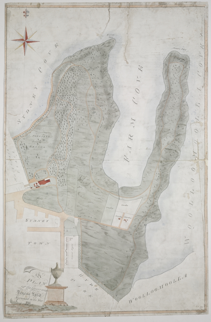
Plan of Governors Demesne Land, surveyed in the year 1816
By
C Cartwright
From the collections of the
State Library of New South Wales
[a2869001 / ZM3 811.172/1816/1]
(Mitchell Library)

Browse

  • Browse
    • Artefacts
    • Buildings
    • Events
    • Natural Features
    • Organisations
    • People
    • Places
    • Structures
    • Entries
    • Multimedia
    • Subjects
    • Roles
    • Contributors
Connections
Appears in
East Circular Quay The Domain The first Government House: building on Phillip’s ‘good foundation’
Subjects
Maps Parks Zoological and Botanical Gardens
Artefacts
Plan of Governors Demesne Land, surveyed in the year 1816
Buildings
First Government House
Natural features
Bennelong Point Farm Cove Mrs Macquarie's Point
Organisation
Sydney Hospital
Places
East Circular Quay Hyde Park Macquarie Place Macquarie Street Mrs Macquarie's Chair Royal Botanic Gardens The Domain

Footer

  • Home
  • About
  • Copyright
  • Contact

Footer Secondary

  • Contribute
  • Donate

Cartwright, C

State Library of New South Wales

East Circular Quay

The area that is now East Circular Quay was quickly seen as the governor's side of Sydney Cove after colonisation in 1788. The first house built on the point belonged to Bennelong. When the semi-circular quay was constructed from 1837, the eastern side of the bay was used as a quarry. From the 1860s, wool stores and warehouses were built that dominated the landscape until after World War II, when taller buildings were allowed.

The Domain

Set aside as part of the Governor's demesne by Governor Phillip, the Domain was formalised by Governor Macquarie in 1816, and has been a people's park, cultural precinct and the scene of political action and dissent ever since.

The first Government House: building on Phillip’s ‘good foundation’

The first Government House was not a simple singular structure but a complex with a yard, outbuildings, guardhouse, garden and greater domain. It was a home, an office and a venue for public and private entertaining, but also a symbol of British authority, with all that that meant to different people, both then and now.

Parks

Zoological and Botanical Gardens

Maps

Plan of Governors Demesne Land, surveyed in the year 1816

full record »

Map drawn by C Cartwright 1816 of the "Governor's Demesne" originally set aside by Governor Phillip.

First Government House

full record »

Residence for the first nine Governors of NSW, which was the first major building in the colony. The first permanent building in the colony, it had two storeys built of bricks and stone comprising six rooms, two cellars and a rear staircase. In front of the house was a garden where many imported plant species were grown and the first orchard planted. The Museum of Sydney, on the corner of Bridge and Phillip Streets, was built on its site.

Bennelong Point

Rocky outcrop to the east of Sydney Cove, which was a tidal island when Europeans arrived, but was joined to the mainland with rocky rubble in 1818 to provide a basis for Fort Macquarie to be built there. The point is named for Bennelong, who lived in a house on the point in the 1790s.

full record »

Farm Cove

Shallow bay on the southern shore of Sydney Harbour, east of Sydney Cove. The flat land nearby was used by Aboriginal people as an initiation ground, and later became the first farm for the European colony.

full record »

Mrs Macquarie's Point

Peninsula in Sydney Harbour between Garden Island and Bennelong Point, named for Elizabeth Macquarie who enjoyed the panoramic views.

full record »

Sydney Hospital

full record »

Hospital founded by Lachlan Macquarie and housed in a number of buildings in Macquarie Street.

East Circular Quay

full record »

Area on the eastern shore of Sydney Cove to Bennelong Point.

Hyde Park

full record »

Park providing green space in Sydney's busy centre.

Macquarie Place

The open space at the corner of Loftus and Bridge streets marked with an obelisk from which roads in the colony were measured. Originally the area was swampy mangrove land on the banks of the Tank Stream it has been a public meeting place since the 1790s.

full record »

Macquarie Street

Street at the eastern edge of Sydney's central business district, designed as a ceremonial thoroughfare by Lachlan Macquarie and containing many of Sydney's public buildings. It was later the best address in the colony, and became a prestigious medical precinct in the twentieth century.

full record »

Mrs Macquarie's Chair

Sandstone bench carved into the rock at Mrs Macquarie's Point, which was used by Mrs Macquarie.

full record »

Royal Botanic Gardens

full record »

Harbourside gardens that combine scientific research with recreation for Sydneysiders.

The Domain

full record »

Park in central Sydney which dates from the colony's earliest days.