
The Dictionary of Sydney was archived in 2021.
Lane Cove

Citation
Persistent URL for this entry
To cite this entry in text
To cite this entry in a Wikipedia footnote citation
To cite this entry as a Wikipedia External link
Lane Cove
The suburb of Lane Cove is approximately seven kilometres north-west of the centre of Sydney. Located on the northern banks of the Lane Cove River, it is part of Sydney's north shore and situated within the County of Cumberland's parish of Willoughby. Lane Cove is a suburb within the Lane Cove local government area.
The original inhabitants of the area were the Cam-mer-ray-gal or Cameraygal group or clan. They were one of the seven clans of the wider Gai-mariagal people, who inhabited the northern shores and beaches of Port Jackson.
Lieutenant William Bradley recorded the first written use of the name 'Lane Cove' on 2 February 1788, soon after the arrival of the First Fleet in Port Jackson. While surveying the area, he referred to the river into which he sailed by this name. The Aboriginal name for the Lane Cove River was Turrumburra.
Several possibilities for the name have been suggested; however there are no primary sources which confirm one theory over another. One theory is that the name was bestowed in honour of John Lane, a good friend of Governor Arthur Phillip and son of Sir Thomas Lane who was Lord Mayor of London in 1694. Phillip was the executor of John Lane's will and they appear to have corresponded regularly. Another theory suggests it was named for Lieutenant Michael Lane, a respected cartographer who worked with Captain James Cook in Canadian waters. Yet another is that the mouth of the Lane Cove River looked just like a narrow laneway and was only an inlet or cove running north from the Parramatta River.
In April 1788, Lieutenant Henry Ball and his small party were the first recorded Europeans to visit the district. He travelled across the high ridge (Greenwich Peninsula) and reported land suitable for future development. Two years later, on 14 February 1790, Lieutenant Ralph Clark landed not far from the entrance to the Lane Cove River. His mission was to establish amicable relations with the Aboriginal people, in order to extract natural resources, such as timber and shells for building and grass for fodder.
Land grants and settlement
The first land grants in the district were issued by Lieutenant-Governor Francis Grose in October 1794. Twenty-seven men from the New South Wales Corps received land grants of 25 or 30 acres (10 or 12 hectares) each. Not all grantees took up their land and so it reverted to the Crown, while other grants were enlarged by purchase or changed ownership.
Early settlers reported resistance to their settlement and attacks by the Aboriginal people. Judge-Advocate David Collins's account of the early colony highlights some of the problems the settlers encountered with Aboriginal people in the district. In May 1797, he stated they
were exceedingly troublesome to the settlers in Lane Cove, burning a house and killing some hogs belonging to one of them. [1]
The Lane Cove River cuts a gorge through the main Hawkesbury sandstone ridge of Sydney's north shore. Freshwater creeks further divide the ridges to form what is locally known as 'the five fingers of Lane Cove' – Greenwich, Northwood, Longueville, Riverview and Linley Point. The steep rocky slopes and ridges are alternated with small estuarine swamps and river flats, where Aboriginal people gathered seafood and Europeans cut grass for fodder and thatch. The slopes and gullies were forested with tall eucalypts, used by settlers for building and flooring. Bluegum, stringybark, blackbutt, red mahogany and turpentine were all prized by early timber-getters.
James Wiltshire was an early settler who had acquired four 30-acre grants (48.5 hectares in total) in the area by 1803. In September 1804, his holdings were attacked by over 200 Cameraygal, [2] and in November 1804 bushfire destroyed about 17 acres (6.8 hectares) of his wheat crop. [3] By 1806, he had sold his four farms to Isaac Nichols, a former convict. Nichols increased his holdings across the district through buying, selling, leasing and the tenanting of his land. Nichols became the colony's first postmaster, and principal superintendant of convicts between 1810 and 1814. Woodford Street, Longueville was originally known as Nichol's Wharf Road.
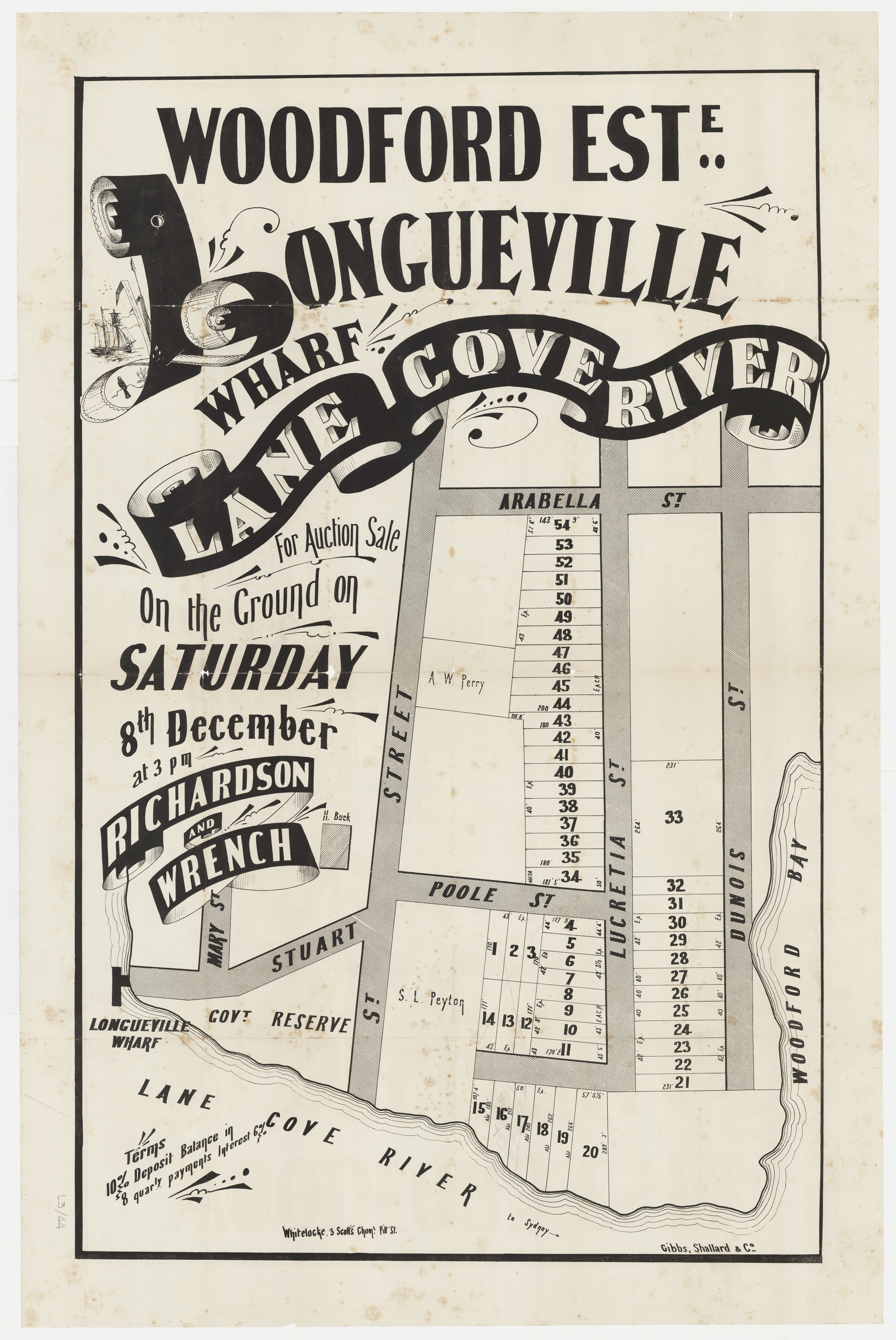
Rupert Kirk, a former captain in the Army Medical Corps, was granted 320 acres (129.4 hectares) in 1831. He named it Woodford Park and established a soap and candle-making manufactory on site. [media]He also attempted to produce tobacco and planted grapes for vinegar production. The depression of the 1840s led him to sell his holdings. Part of his estate was subdivided into allotments and advertised as 'Woodford Terrace, North Shore'. [4]
Local government
[media]When the municipality of North Willoughby was proclaimed in October 1865, it was divided into two wards, with the Lane Cove district forming the River Ward. In February 1885, 150 residents petitioned the Colonial Secretary, asking for River Ward to be separated from North Willoughby to allow local self-government, but this fell on deaf ears. Residents of the Lane Cove Ward again petitioned for self-government in 1893, and in February 1895 the new municipality of Lane Cove was proclaimed.
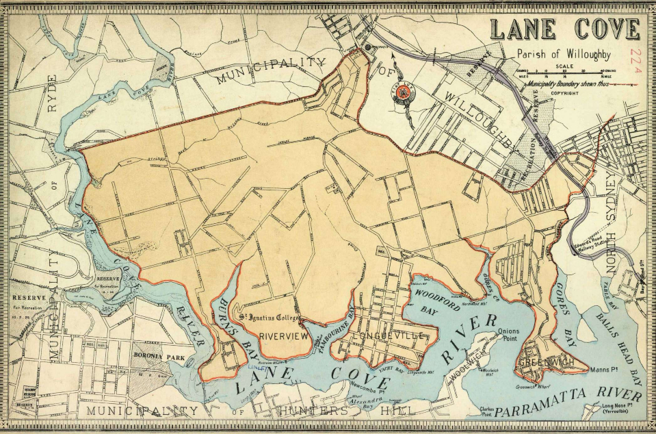
Early references to the Lane Cove district placed it in the western portion of the district of Hunters Hill, but for much of the nineteenth century the district named Lane Cove referred to the whole of the area on the northern banks of the Lane Cove River, from Greenwich to Gordon. When the first Lane Cove Post Office opened in 1860, it was in fact located in present-day Gordon, and was not renamed the Gordon Post Office until 1890. It was only after municipal incorporation in 1895 that 'Lane Cove' came to signify the present-day area of Lane Cove. Originally the area of today's Lane Cove was called Longueville, because the nearest post office was Longueville.
Roads, bridges and transport
Access to the district, for early residents, was only by water. There were a number of failed attempts to establish a regular ferry service to Sydney in the 1830s and 1840s, but the first successful one was owned by Hunters Hill resident, Didier Joubert. He began a ferry service along the Lane Cove River in the 1850s. In 1906 Joubert's company was sold to Balmain New Ferry Company and later to Sydney Ferries, who maintained services up the Lane Cove River until the 1950s. Sydney Ferries continue to provide a service to Greenwich Point, which is their only stop on the north side of the Lane Cove River.
There were a number of attempts at regular ferry services further upstream from Greenwich, but most failed. One successful business was run by Rosman ferries and operated until 1987. In 2011 Matilda Cruises was running a weekday service along the Lane Cove River with stops as far as Riverview.
The local topography determined the location of the earliest roads through the district. Most tracks commenced from the wharves and landing places in the bays and led via the easiest routes up the ridges, eventually connecting to the track along the main ridge from Blues Point, North Sydney, to Hornsby. Originally named Gordon Road or Lane Cove Road, it is now the Pacific Highway.
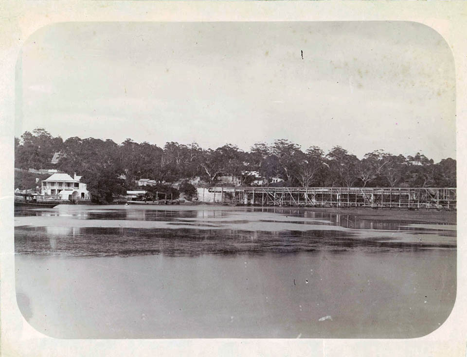
[media]In 1885 the first bridge crossing the Lane Cove River was opened. Named the Fig Tree Bridge, it linked Linley Point to Hunters Hill. It was an opening bridge, built of iron trusses. The first Gladesville and Iron Cove bridges also opened early in the 1880s and the combination of the three bridges provided the first road link from Lane Cove and the north shore to Sydney and districts south of the harbour.
Horse-drawn vehicles – buses, wagonettes or omnibuses – were the earliest form of bus services operating on the north shore, from the 1870s. First begun by land developer Richard Hayes Harnett, the service operated from Milsons Point ferry wharf along the then Lane Cove Road (Pacific Highway) to the Greengate Hotel at Pymble and on to Hornsby. From 1902 Northwood entrepreneur John Richardson operated a service from Best Street, Lane Cove, to Gore Hill. The next year it was extended to Hunters Hill, and another started from Longueville to Chatswood. Robert Austin of Lane Cove also ran two horse-buses from Fig Tree (Hunters Hill) to Gore Hill between 1905 and 1909.
The north shore rail line from Hornsby to St Leonards opened on 1 January 1890 and was extended to Milsons Point in May 1893. In 1927 testing for the introduction of electric trains began and by 1928 a full-time electric service was operating on the line. Another rail line, linking St Leonards with the Epping/Eastwood area through North Ryde was proposed from 1889, and despite Acts of Parliament authorising construction in 1927 and 1930, the plan was dropped in favour of a road link.
An electric tram service began running from Crows Nest to Gore Hill in 1900. Soon afterwards, the Lane Cove Progress Association began lobbying for the extension of the service into their expanding residential area, but it was not until 1908 that approval to extend the line was granted. In March 1909 the extended tram line to the northern junction of Longueville and Burns Bay roads began operating. This new terminus was named Lane Cove rather than Longueville. In 1957 a review of Sydney's public transport recommended that bus services replace trams, and trams ceased to operate on the Lane Cove line in June 1958.
From colonial times, a crossing of Sydney Harbour to link the North Shore to the city was often proposed, but it was not until after World War I that serious plans were made. Construction of the Sydney Harbour Bridge commenced in 1924 and was finally completed in 1932. The bridge allowed for trains, trams and vehicular transport to cross the harbour, and its opening contributed greatly to the further subdivision and settlement on the north shore and in the Lane Cove district.
When plans for the promised St Leonards to Epping/Eastwood railway were abandoned after the 1930s Depression, public unrest was apparent. Many had subdivided land and moved into the district on the promise of the new railway. In 1936 the Member for Ryde, Eric Sydney Spooner, promised 'a first class concrete road' instead. [5] In 1938 construction began and in 1939 a new bridge built across the Lane Cove River completed the link to Epping, through North Ryde. Originally known as Spooner Highway, it is now Epping Road.
In 1963 the original Fig Tree Bridge across the Lane Cove River was replaced by a new girder and concrete bridge. It comprised seven spans, each of 100 feet (30.4 metres) and was located 50 metres to the east of the original bridge. It was built as part of the new North-western Freeway, which included the new Gladesville and Tarban Creek bridges and the overpass at Hunters Hill, and allowed for increased volumes of traffic.
As early as 1951 the County of Cumberland Planning Scheme proposed a road to link the Warringah Freeway to the Pacific Highway at Lane Cove. The land corridor was gazetted in 1953, but it wasn't until the 1970s that a construction proposal timeline was announced. The link road became a reality in the 1980s with funding under the Bicentennial Roads Program. Construction commenced in August 1988 and the Gore Hill Freeway opened to traffic in August 1992. [6]
The Lane Cove Tunnel project was the final link in the Sydney Orbital Network. It proposed a tunnel beneath Epping and Longueville roads to link the M2 Motorway and the Gore Hill Freeway. In June 2004, construction of the 3.6-kilometre twin tunnel started and it opened in March 2007. It is a toll road that diverts much of the through traffic from the main roads of Lane Cove.
Industry
The earliest industries in the district were important to the building of the new colony. Timber-getters cleared the forests of the north shore. Emancipist William Henry was one of the earliest timber-getters in the Lane Cove River valley. His 1000-acre (404.6-hectare) leasehold covered much of the Linley Point area, and the route his bullock carts took dragging timber to the river forms the present-day Burns Bay Road. Grass-cutters provided much-needed fodder for the colony, as well as thatch for roofing. Shell middens along the shores were easily accessible to lime-burners, who produced lime for mortar for the building industry.
Before long, the cheap waterfront land cleared by the timber-getters and grass cutters proved to be the ideal location for other industries. The Lane Cove River gave easy access to city markets and the numerous creeks provided a plentiful supply of fresh running water. The pollution or effluents caused by early industries were of little concern to the sparsely scattered residents of the time.
Rupert Kirk's soap- and candle-manufacturing business began in the 1830s, and in 1858 John Charles Ludowici and Albert Radke moved their tannery business from Balmain to a secluded 16-acre (6.4-hectare) site on Burns Bay in the Lane Cove River. The creek where they established their factory was soon known as Tannery Creek. In 1861, they dissolved their partnership and began operating separate tanneries on either side of the creek. Both companies continued to operate until 1941 when Radke's remaining land, buildings and equipment were sold to JC Ludowici & Son. Ludowici's ceased its tannery operation in 1967, and by 1974 had moved all associated works and offices to Castle Hill.
Charles Ludowici, son of John Ludowici, formed a separate company in 1913 to manufacture leather transmission belts for factories, at an adjoining south-western site on Burns Bay. The company, Mangrovite Belting Ltd., continued to operate at the Burns Bay site until 1974.
The Australian Wood Pipe Company also established a factory on the western side of Burns Bay in 1914. It made the 'Pioneer' brand of wood pipes. Charles Ludowici was one of the original subscribers of the company. The pipes were constructed from oregon or karri timber, dressed both sides and bound with a heavy gauge machine-wound galvanised steel wire, covered with heavy asphaltum and then sawdust. The diameter could be up to 60 inches (1.5 metres) and the length varied from 8 to 16 feet (2.4 to 4.8 metres).
During the nineteenth century, crockery and pottery were important utensils for the storage and serving of liquids and food. The clays from the headwaters of Gore Creek proved ideal resources for this type of industry. The Phoenix Pottery Company was established in 1883 by Samper & Lacy at the intersection of Nichols Bay (now Longueville) Road and Little Street. A second pottery works, the Sydney Pottery Company, was established nearby in Phoenix Street in 1886 by Thomas Wilkes. Both companies had a number of ownership and name changes, but are today remembered for their traditional-shaped glazed teapots, Toby jugs and money boxes. Pottery Green Reserve in Lane Cove commemorates this early industry established in the area.
Orchards and dairies were the district's main rural industries, and river transport provided easy access to the city markets. William Pendry of Northwood was one of the earliest orchardists, growing approximately 20 acres (8 hectares) of stone fruit trees on his property. By the late nineteenth century, many dairies were established throughout the district. Elijah Charlish was one who was known for his orchards and dairy as well as his pigs and poultry.
Subdivision and settlements
At the beginning of the twentieth century, Lane Cove was still largely undeveloped. The 1901 Census listed only 301 dwellings, occupied by less than 2,000 residents. By 1914 the population had increased to 4,600. The post-World War I subdivisions included pockets of housing built by the Commonwealth War Service Homes Commission for returned servicemen. Land subdivisions for housing occurred at a rapid rate, with new residents being lured by the promise of extended tram services linking the area with Ryde or Hunters Hill and a planned railway from Eastwood to St. Leonards. The opening of the Harbour Bridge in 1932 greatly improved access to and from the city, but development was still slow, largely due to the 1930s Depression.
In the years following World War II, rapid changes and increased residential and industrial development occurred. The first block of flats was built in 1962 and by 1979 nearly 200 blocks of flats had been built along the main roads around the Lane Cove village. [7] The residential area of Lane Cove has retained a single-house character into the twenty-first century.
Churches and schools
Despite the sparsely populated rural nature of the early district, a place of worship was important to the early settlers. Early services by visiting clergy of various denominations were held in local homes.
In 1871 the Chatswood South Methodist Church was completed. Now called Chatswood South Uniting Church, it is a gothic-style sandstone church with adjoining churchyard cemetery. It is the oldest remaining Methodist church on the north shore and the burial place of many pioneer families. In 1923 additional Methodist services commenced in Lane Cove's War Memorial Hall. A site in Finlayson Street was purchased and Lane Cove Methodist Church opened in 1925. A new church building opened in 1960. This later became the Finlayson Street Uniting Church.
The Lane Cove Congregational Chapel was erected on Longueville Road in 1878, and in 1921 a larger church hall was added. With the inauguration of the Uniting Church of Australia in 1977, the congregation became part of the new church. The final service was held in June 1977 and the hall continues to be used as part of the Kamilaroi Retirement Centre.
Presbyterian services and Sunday schools began in a tent on Burns Bay Road in 1913 as part of Longueville parish. A brick church was built nearby and opened in 1915, and it became an independent parish in 1924. Originally named the Burns Bay Church, it became St Columba's Presbyterian Church and in 1977 it became St Columba's Uniting Church.
The Anglican parish in Lane Cove was established from 1921, and St Andrew's Church of England was completed in 1923. In 1966 it was converted to a hall, and a modern hexagonal church building was built on an adjoining site.
In 1922 a new Catholic parish of Lane Cove was established. St Michael's Catholic church was built in 1926, replacing a smaller structure. In 1976, a contemporary church building was built on the site.
After the establishment of a Provisional School at Greenwich in 1876, Longueville residents petitioned for a school for their children, and one was established in 1876 at Woodford Bay. In 1878 it was transferred to the Congregational Chapel, Longueville. A two-acre (0.8-hectare) site adjoining to the north was purchased and by 1882 a public school was built. In February 1921 the school's name was changed from Longueville to Lane Cove Public School.
In 1878 the Jesuit Fathers (Society of Jesus) purchased 33 acres (13.3 hectares) of land between Tambourine and Burns bays, Lane Cove, and St Ignatius' College opened with 12 students in 1880. By 1889, a four-storey landmark building was erected on the ridge overlooking the river. Originally a boarding school, St Ignatius' College Riverview now enrols both dayboys and boarders from years 5–12.
St Michael's Catholic school was established in St Michael's Catholic church in 1922 by the Mercy Sisters from Monte Sant' Angelo, North Sydney. In 1928 a separate convent was established nearby and by 1953 a new St Michael's school was opened on the present site. From the 1950s it educated boys to lower primary and girls up to Intermediate level (Year 9). The 1960s Wyndham reforms rationalised Catholic education and brought the school under the supervision of the Catholic Education Office. It now offers primary education to boys and girls from kindergarten to Year 6.
Currambena is an independent primary school and preschool which has operated in Lane Cove since 1969. The school's child-centred philosophy emphasises creativity and flexibility in responding to the needs of individual children. It offers an 'alternative' education to children from all over Sydney.
Community
Lane Cove Council was the first local government body to introduce a Community Aid Service in 1961. It was the idea of Alderman Claudia Leach and the model was soon adopted by other local government areas across the country. It also began 'meals on feet' deliveries to the infirm. By 1965 this had become the 'Meals on Wheels' service. [8]
Lane Cove has a legacy of natural bushland pockets throughout, in its many parks and reserves. The Lane Cove Council was one of the first local government areas to recognise the need for bushland management and introduced programs of bush regeneration and weeding, utilising the Bradley method of bush regeneration in the late 1970s. [9]
Lane Cove Plaza, opened in 1977, was the first pedestrian mall created in New South Wales by closing off part of a main street. It was regarded as 'a bit radical' [10] because it closed off a section of Burns Bay Road to all traffic. Since its inception, the Plaza has become an integral part of Lane Cove village life and atmosphere. It regularly hosts musical entertainments and public meetings. It is used extensively as a venue for local events where residents can relax at outdoor dining places or public spaces.
References
Bridge building in New South Wales 1788-1938: Extracts from December 1950, September 1951 and December 1954 issues of Main Roads, Journal of Department of Main Roads New South Wales
D Benson and J Howell, Taken for granted: The bushland of Sydney and its suburbs, Kangaroo Press, Kenthurst NSW, 1990
J Dargan, Claudia: An authorised biography of Claudia Leach, Lane Cove Library, Lane Cove, 2003
Gore Hill Freeway: Construction information, Ozroads: The Australian roads website, 2000-2004, http://www.ozroads.com.au/NSW/Freeways/GoreHillFreeway/ConstructionInfo.htm, viewed 12 October 2009
D Keenan, The North Sydney lines of the Sydney tramway system, Transit Press, Sans Souci, 1987
'Lane Cove Council: Administrative history, July 2005', unpublished, 2005, held Lane Cove Local Studies and Archives
E. Ludowici, The family history 1629–1998, Styfox, Sydney, 1998
R Moore, P Pike, and L Tropman, Municipality of Lane Cove heritage study, Lane Cove Council, Lane Cove, 1993
J Pagett, Pioneer industries of Lane Cove, the author, Northwood, 2006
W Polglase, St Leonards Railway Station 1890–1995, Lane Cove Library, Lane Cove, 2007
E Russell, Lane Cove 1788, 1895, 1970: A North Shore history, Lane Cove Municipal Council, Lane Cove, 1970
E Russell, A Century of Change – Lane Cove Municipality 1895–1995, Lane Cove Council, Lane Cove, 1995
A Tate, Ludowici Limited: Pioneering the past, forging the future 1858–2004, Allen & Unwin, Sydney, 2005
Notes
This entry was revised in January 2019 removing the reference to a convict stockade existence at Woodford Bay which has not thus far been verified in any primary source documentation, and to clarify the ongoing confusion often caused by historical records citing Lane Cove as a location. Up until the early twentieth century, the location of Lane Cove generally refer to anywhere in the large area on the northern side of the Lane Cove River extending from the present Longueville through to Gordon and not just the present Sydney suburb of Lane Cove.
[1] D Collins, An account of the English colony in New South Wales, Sydney, AH & AW Reed, 1975, p 25
[2] Sydney Gazette, 2 September 1804, p 2
[3] Sydney Gazette, 11 November 1804, p 2
[4] Australian, 4 May 1841, p 3
[5] E Russell, A Century of Change: Lane Cove Municipality 1895–1995, Lane Cove, Lane Cove Library, 1995, p 27
[6] Gore Hill Freeway: Construction information, Ozroads: The Australian roads website, 2000-2004, http://www.ozroads.com.au/NSW/Freeways/GoreHillFreeway/ConstructionInfo.htm, viewed 12 October 2009
[7] R Moore, P Pike and L Tropman, Municipality of Lane Cove heritage study, Lane Cove Council, Lane Cove, 1993, vol 1, Appendix B, p 112
[8] J Dargan, Claudia: An authorised biography of Claudia Leach, Lane Cove Library, Lane Cove, 2003, p 78
[9] D Benson, J Howell, Taken for granted: The bushland of Sydney and its suburbs, Kangaroo Press, Kenthurst, 1990, p 116
[10] E Russell, A Century of Change: Lane Cove Municipality 1895–1995, Lane Cove Library, Lane Cove, p 45
.