The Dictionary of Sydney was archived in 2021.
Como
Citation
Persistent URL for this entry
To cite this entry in text
To cite this entry in a Wikipedia footnote citation
To cite this entry as a Wikipedia External link
Como
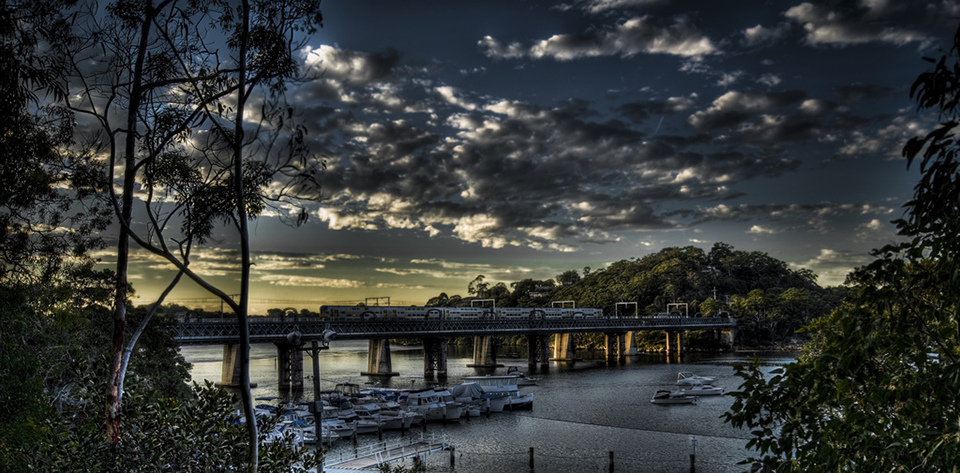
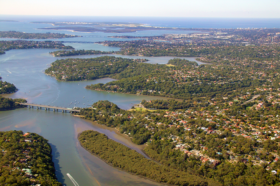
Como is [media]located on the southern banks of the Georges River. Hawkesbury sandstone forms the basis of the geology of the area, which makes it unsuitable for agriculture. However, natural bushland ridge tops and sandstone outcrops provide excellent vistas to the river and bays and Como is attractive with its low-density residential development and water-based leisure activities.
Como is the first Sutherland Shire township and railway station. It is crossed by the Illawarra railway line and lies between the Georges and Woronora rivers. The southern and eastern boundaries appear to follow the paddock fence lines originally established in the nineteenth century by the pioneer Thomas Holt. It also includes the area referred to as Como West.
The earliest inhabitants of Como were the Dharawal people, and the area would have first been sighted by European explorers from the water. In 1788 Captain John Hunter surveyed the Georges River to a point past Como. Matthew Flinders and George Bass made sketches of the river on their explorations in 1795. Surveyor Robert Dixon charted the Georges River and parts of the Woronora River in 1828. However these early explorations did not lead to permanent settlement at the time.
Where two rivers meet
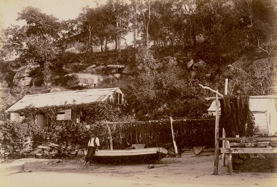
The Georges River offered a haven to [media]fishermen and lovers of oysters, who were attracted to this area to fish and collect oysters from the naturally occurring beds. Boating parties of sportsmen and fishermen frequented both the Georges and Woronora Rivers and would have passed by the headland which would become the township of Como. [1] In 1869 a family rested at a cave known as Old Woman's Bonnet (a feature first noted by the explorers Hunter and Dixon on their way upstream along the Woronora River) now in the area known as Como West. [2] By 1870 however, the removal of oysters from the whole of Georges River was stopped by the government, as they had come close to extinction. This ban remained in place for several years.
Thomas Holt purchased much of what is now Sutherland Shire. In the 1860s it was known as the South Botany Estate and was divided into 11 paddocks. The township of Como was created from three double bay paddocks. It was noted that the whole of one paddock near the water was 'very rocky' and generally the area was well scrubbed, having at one time been used to graze sheep. [3]
Railway to the south
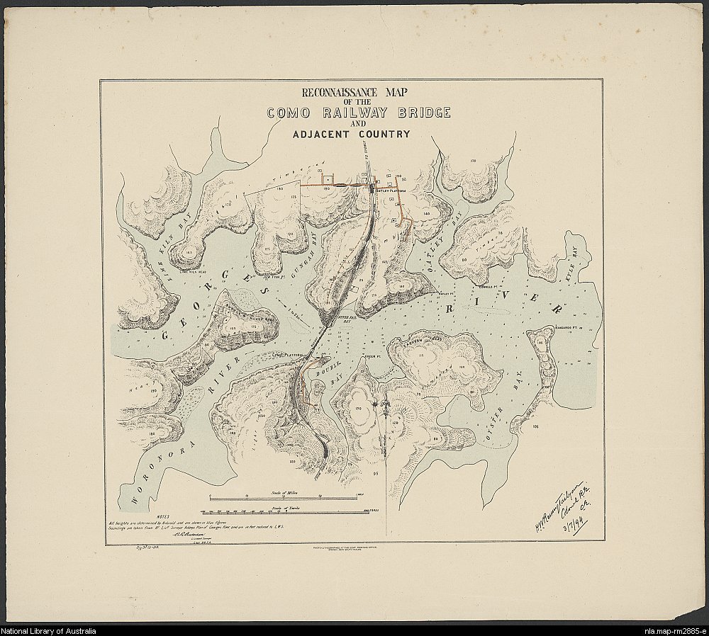
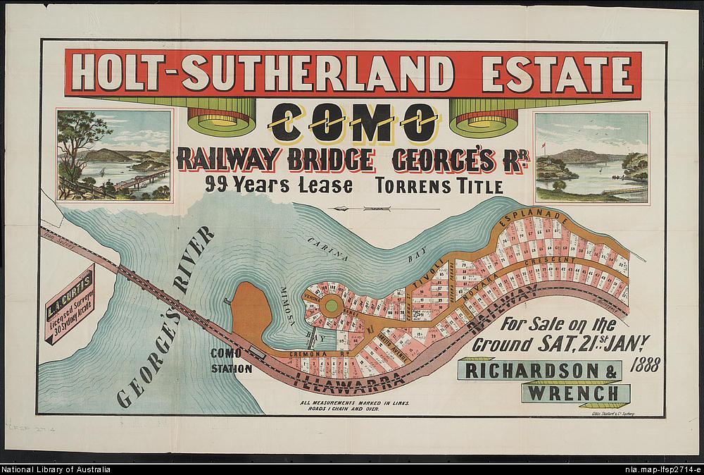
Plans to [media]build a railway line to the Illawarra district in the south were announced in 1881, providing the impetus for an influx of visitors who were no longer restricted to water transport. At this time, Holt had leased most of his estate to a newly formed company known as the Holt-Sutherland Estate Land Company (1882–95). However Holt, being a keen advocate of urban development, let the company know that he supported the proposal to construct the railway line through the estate. After much discussion, tenders were called for the first section on 12 September 1882. C and M Millar won the contract to build the section from Redfern to Waterfall, crossing the Georges River and into the estate via the Double Bay paddock.
A railway camp was quickly set up on the southern shore. By 1883, Thomas Handley was operating a 'humble hostelry' close to the camp, known as the Woronora Hotel. It also housed the first postal service which commenced in the same year. A population of about 120 adults and children lived and worked in the railway camp and this number rose to many more as the line progressed. James Murphy, the manager of the Holt-Sutherland Estate Land Company, suggested Como for the name of the post office. It is said that Murphy's choice was based on the area's likeness to the lake of the same name in Italy. A school opened on 16 April 1884 under the name Worinora and less than a month later, it too became known as Como.
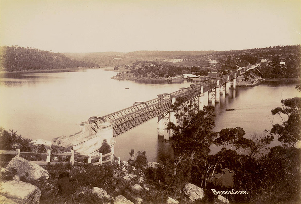
In [media]March 1885 it was noted that land sales were to take place in anticipation of interest in the area when the train line opened. The land in question was on the Holt-Sutherland Estate and gangs of men were employed to clear blocks of land along the shores. [4] By May 1885, the railway workers were steadily moving up the line with the bridge all but completed. Deemed to have one of 'the most beautiful railway bridges in the world', the railway line was opened in December 1885. [5]
The day tripper comes to Como
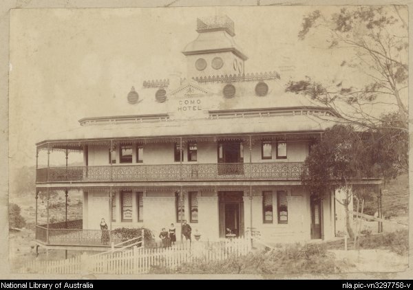
Even [media]before the railway crossing bridge was complete, tourists were walking over the unfinished portion. [6] By January 1886, guidebooks deemed Como to be one of a number of attractive resorts along the Illawarra line. Pleasure grounds and rivers suitable for boating were popular places for people from the city to spend their leisure time, and Como was the ideal spot for both. Holiday folk were to come in their thousands. The Holt-Sutherland Estate Land Company provided a substantial wharf and several boats for recreational rowing. [7] James Murphy created a pleasure ground on the tiny headland near the railway bridge and it was not long before other boat sheds were set up to complement the pleasure grounds. In 1890, a [media]new and grander hotel, known as the Como Hotel, was opened to replace the Woronora Hotel which had closed in 1887.
The paddle steamer Telephone commenced operation in 1899 from the western side of the railway line ferrying passengers to pleasure grounds further down the Georges River.
Como, the 'coming suburb'
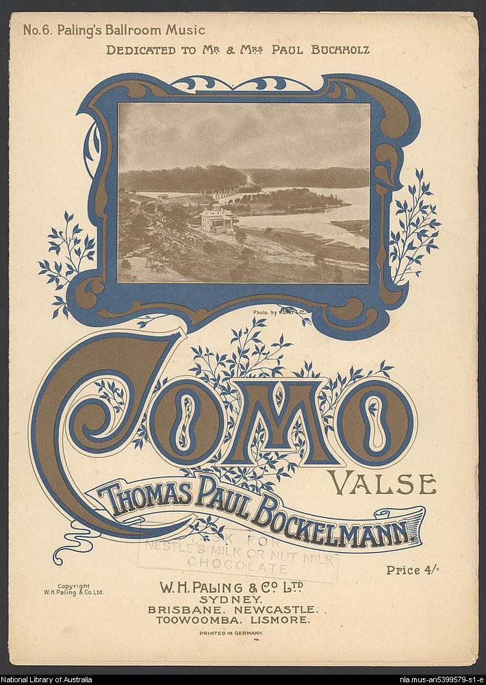
The [media]time was now right for the release of subdivisions, and the Holt-Sutherland Estate Land Company was the first to offer land for sale in 1888–89. In 1905 Paul Buchholz took over the Como Hotel, which became a weekend tourist destination for the wider community. It was also used as a meeting place for Germans living along the Georges River. At about this time, a musical piece, the Como W altz, was composed by Thomas Paul Bockelmann and dedicated to the publican and his wife.
In 1907 the newly formed Sutherland Shire Council inspected the Como area on both sides of the railway line to determine the best location for an access road. It was decided that the western side provided the best option. However it took some time for roads to and within subdivisions to be constructed. Sutherland Shire Council called for tenders to clear and form a road between Sutherland and Como in 1912, but the process did not commence until much later. As one resident later stated, the 'street names were there in the bush, put there by the Estate agents … but trees had to be cut down to make a track through the bush'. [8] Life was hard with few services or facilities available for the local residents.
According to Larkin, [media]land that was close to the station had more appeal for development in Como. In 1914 a syndicate purchased about 135 acres (55 hectares) of land from the Holt-Sutherland company. Promoted as 'the coming suburb', the river blocks sold well, although land was still being advertised into the 1920s. [9]
A progress association was formed in 1913, with one of the main aims being to establish a school, as the first school had closed before the railway bridge had even opened. A request was made in 1915 but it was unsuccessful.
In 1919 money was granted by the federal government to build the road between Sutherland and Como on the proviso that returned soldiers from World War I were employed to undertake the work. The route was decided and approved by Sutherland Shire Council and came to be known as Soldiers Road. It linked Sutherland to the western side of Como and was officially completed in 1920.
It became [media]clear that the growing population was sufficient to warrant a public school, which opened in 1920. The community then rallied together to lobby for a school of arts building, to provide a meeting place for social occasions, and in 1921 Como was officially declared a village. A police presence was consolidated with the establishment of a police station at Como in the early 1920s. Until a few shops were established, however, residents still needed to travel to services closer to the city, and were reliant on a limited train service if they did not own a car.
The Depression
Como provided a number of opportunities for relief works during the depression of the 1930s. The largest project, which was to have a huge impact on the Como landscape, was the filling of Scylla Bay. This meant that visitors were no longer able to row or sail a boat to the shore below the Como Hotel. This reclamation work lasted well into the 1940s and the reclaimed area became playing fields, which are still heavily used.
A decision was taken in 1929 to link Sutherland and Como on the eastern side of the railway line and the necessary road works began in the 1930s with funding from the state government's 'Spooner scheme' for unemployment relief. Many families moved into the Sutherland Shire, relocating from as far afield as the city. One family moved from Oatley to live in a humpy at the 'Bonnet', once used as a fisherman's shelter. [10]
World War II had a big impact on the recreation industry which had thrived in the early part of the century. In March 1942, boats in Como were taken away as a wartime security measure and boat shed operators were ordered to demolish some of their buildings and pontoons. [11]
Henry Lawson and the identity of Como
The later development of the Como area saw a gradual improvement of services for a growing population in a postwar setting. At the same time the community actively preserved its historical identity, local culture and landscape. In 1954 a park centrally located in the suburb was dedicated to Henry Lawson who was said to have been a regular visitor to the Como area, particularly around the 'Bonnet'. For a number of years, concerts with an Australian theme were held in the park. The Como pleasure grounds, which had been in decline, were rejuvenated under the care and of the Council, and remained a central focus of the area.
Although there had been some agitation in the 1930s for a road bridge to be built alongside the railway crossing, this was never realised.
The last major transport improvement came in 1972 with the opening of a new railway bridge to cater for an increase in demand for rail services to and from the south. The old railway bridge was adapted for re-use as a cycleway and walkway in 1985.
The [media]local and wider community was dealt a blow in 1994 with a devastating bushfire, and again in 1996 when the iconic Como Hotel was burnt to the ground. A heritage-listed building, the hotel had graced the foreshore of Como for over 100 years. A new hotel was built on the site to replicate the original and to retain the leisure and recreational function of the area. Today Como remains popular with visitors and residents alike.
Notes
[1] RC Walker, Sutherland Estate Report, SLSN, 1868, p 72
[2] Quarterly Bulletin, Sutherland Shire Historical Society, Miranda NSW, August 1985, p 125
[3] RC Walker, Sutherland Estate Report, SLSN, 1868, pp 69–70
[4] Town and country Journal, Frank and Christopher Bennett, Sydney, 28 March 1885, pp 639–40
[5] Sydney Morning Herald, 28 December 1885, p 7
[6] Town and country Journal, 18 April 1885, p 795
[7] Sydney Morning Herald, 28 December 1885, p 7
[8] M Coulthard, Early Como: Reminiscences, nd
[9] M Larkin, Sutherland Shire: a history to 1939, Jannali NSW, 1998, p 45
[10] Marion Caesar, interviewed by Merle Kavanagh 22 February 1995 for Sutherland Shire Libraries
[11] M Larkin, 'Como: A boating resort since the 1880s', unpublished essay, 1991, p 15
.


