
The Dictionary of Sydney was archived in 2021.
Sydenham

Citation
Persistent URL for this entry
To cite this entry in text
To cite this entry in a Wikipedia footnote citation
To cite this entry as a Wikipedia External link
Sydenham
Sydenham, a suburb of the Marrickville local government area, is located six kilometres south west of Sydney. The traditional owners of the land were Cadigal of the Eora nation.
Sydenham was named after the London suburb of Sydenham, part of the inner London borough of Lewisham. Sydenham is only two kilometres from Kingsford-Smith Airport and lies directly under the flight path of the third runway, constructed 1992–94. A large segment of Sydenham no longer exists as it was deemed uninhabitable because of aircraft noise. One hundred and fifty two homes, covering an area of 4.5 hectares, were acquired and demolished by the Commonwealth Government. Demolition began on 27 September 1995 amid large protests which prevented the work from proceeding for several days. Significant heritage buildings were retained. The resulting vacant land was named Sydenham Green. It is replete with symbols of the loss of this old residential area.
The history of Sydenham is tightly interwoven with the neighbouring suburbs of St Peters and Tempe. These triplet suburbs share common characteristics of development, which are not easily unravelled.
Early European settlement
Most of the western half of Sydenham was within the Gumbramorra Swamp, a local Aboriginal name, which provided an effective boundary for the early European land grants. The majority of Sydenham stands within Thomas Moore's Douglas Farm, granted in 1799. Thomas Moore was one of the largest landowners in the area.
Another grant of 30 acres (12.1 hectares) was made in 1799 to emancipated convict, John Fincham but it was virtually useless land as it was entirely contained by the swamp.
The Gumbramorra Swamp
The Gumbramorra Swamp emptied into the Gumbramorra Creek and then into Cooks River. Part of Sydenham and the suburbs of St Peters and Tempe developed to the south east of the swamp and the suburb of Marrickville to the west of it. Gumbramorra Swamp consisted of marshland at the foot of the declining sandstone and shoal ridges of Marrickville, in a relatively narrow area surrounded by low hills. At the mouth of the Gumbramorra Creek were mudflats, which were also evident in the swamp itself. Behind these mudflats and mangroves was the characteristic salt marsh. These conditions supported abundant wildlife. The Gumbramorra Swamp was a good source of food for the Aborigines.
The swamp was of indeterminate size. In wet seasons, it covered a wide area but contracted in dry seasons to half of its maximum size. The Gumbramorra Creek was a poor drain as it tended to keep water in the swamp.
By the 1840s a track led away to the west with the descriptive name of Swamp Road. This is now Sydenham Road. A trip east along Sydenham Road towards Sydenham Railway Station will find blocks of freestanding single-storey houses, small semi-detached cottages, Federation houses, parks, and corner shops suddenly giving way to factories and factory outlets. The traveller will know by the changed landscape that they have crossed the boundary into the former swampland.
Another early road along the eastern boundary of the swamp was Unwin's Bridge Road, so named as it led to Unwin's Bridge across Cooks River at Tempe. The original Unwin's Bridge was constructed by convict labour in 1836 for Frederick Wright Unwin, who had land on both sides of Cooks River and needed a safe crossing. In the early 1850s Unwin's Bridge Road was laid out and designated as a government reserve road. Unwin's Bridge Road is still a main thoroughfare through Sydenham, passing Sydenham Green.
What made the swamp attractive to the original inhabitants was precisely the reason why European settlers avoided it. They did not understand its importance to the local ecology and saw it only as a source of drinking water for their cattle or useful in the establishment of brick making along Sydenham and Unwin's Bridge roads.
The Tramvale disaster
In 1881 the tramway was constructed along the western boundary of the swamp, now Victoria Road. Part of the original line for the tramway was laid down in the swamp as an incentive to development.
The Tramvale subdivision was then offered for sale in 160 lots with double frontages. The subdivision targeted the working class, stressing the availability of employment within 'a centre of a manufacturing district' with a 'certainty of a rise in value'. The estate was badly designed, afflicted with regular flooding and poor drainage. It lacked basic sewerage facilities. Tramvale was notorious for its stench, which the breeze carried all the way to nearby Marrickville, St Peters and Tempe. Its inhabitants also suffered from a range of diseases, including typhoid fever. In summer the mosquito plagues reached epidemic proportions.
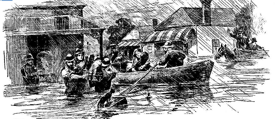
The [media]stressed owners of Tramvale would never see a return on their investment. After five days of heavy rain in May 1889, Cooks River flooded and the water rushed up Gumbramorra Creek and into the swamp. Tramvale was the worst hit, with residents having to be rescued as their homes went quickly under water. There was a public outcry and questions were raised in the NSW Parliament about the ethics of developers who sold cheap land, which was both unhealthy and subject to regular flooding, to working-class people, who would never be able to resell.
The drainage of the Gumbramorra Swamp and industrialisation
Tramvale was never rebuilt. It was recognised that this low-lying land was better suited to industry. The drainage of the Gumbramorra Swamp commenced in the 1890s. A steam pumping station in Carrington Road was built in 1897 and three brick drains with concrete capping and bottoms were constructed through the swamp to Cooks River. Together with improved street drainage and holding ponds the swamp was reduced to level land.
[media]During the Great Depression of the 1930s, a large brick-lined drainage pit to take the overflow from stormwater drains to Cooks River was built in Garden Street, Sydenham as a relief work scheme. Now a listed heritage item, the brick stormwater basin can be seen from the rail line at Sydenham.

The new land out of the old swamp attracted engineering and other heavy industry such as Sydney Steel. The opening of the railway at Sydenham also contributed to the industrialisation of the western half of Sydenham. On the eastern side of the railway line, the residential suburb of Sydenham flourished. Many of these residents provided the labour force for the local factories.
Sydney Steel was one of the major factories built after the swamp was drained. It was founded in 1910 by Scottish migrant, Alexander Stuart, who also served several terms as Mayor of the former St Peters Council in the late 1890s. The Sydney Steel Company played a unique role in both local and city construction, including the Sydney Dental Hospital, the Sydney Morning Herald building and the Qantas building. Sydney Steel also provided some of the softer steel for the Sydney Harbour Bridge and the MA Noble Stand at the Sydney Cricket Ground. During World War II Sydney Steel provided the caissons for a 250-ton crane at the Sydney naval dock as a service to Australia.
By the 1930s Sydney Steel covered 11 acres (4.5 hectares) and was the largest employer of labour in the Marrickville municipality with over 7,500 employees. It ceased operations in the local area in the 1960s. A clothing warehouse now operates on part of the site in Sydney Steel Road.
The railway suburb
Sydenham Railway Station was opened in 1884. It was known as Marrickville Railway Station until the opening of the Bankstown line in 1895. With the opening of a station actually at Marrickville, the original Marrickville Railway Station was renamed Sydenham.
The opening of Sydenham Railway Station was a major event with a special train put on. Excited locals celebrated by roasting a whole bullock in a nearby paddock and holding contests such as chasing a greasy pig or climbing to the top of a greasy pole. The prize was a rooster in a bag.
Sydenham is an important junction station on the Illawarra, East Hills and Bankstown lines of the City rail network. The station is a significant collection of heritage-listed buildings, which illustrate the evolution of railway station architecture from the elaborate 1880s structures through the standard suburban-type building to the functional designs of the 1960s.
A small shopping centre developed around Sydenham station which provided the necessities of life for the local community and for commuters. There are also several heritage-listed corner shops throughout the suburb. The corner shops date from the late nineteenth to the early twentieth century and were common in lower cost housing developments of this period. They form an important part of the social history of Sydenham.
Sydenham Railway Station has seen more than its fair share of human drama. In 1901 nine people were killed in a dramatic accident that involved the 6 pm train's engine somersaulting through the air. In 1953 another train disaster just before Christmas killed five people, and injured over 200.
The development and divisions of Sydenham
Residential Sydenham was mainly east of the railway line and the industrial sector was mainly west of the line. There was some crossover of residential and industrial development along Unwin's Bridge Road.
After the subdivision of the early land grants, Sydenham, to the east and outside of the swamp, enjoyed an era of large villa estates, mainly along Cooks River Road (now Princes Highway). From the 1830s onwards, wealthy Sydney businessmen built large country retreats along the road to escape the pressures of living in Sydney.
One of the largest of these villa estates was The Grove, built in the 1850s for John George Church, a merchant of the firm Church Bros. Church was a colourful identity, often referred to by his business associates as 'Squatter John'. The Grove estate occupied all of the land from Unwin's Bridge Road to the Princes Highway, between Reilly and Grove Streets.
The Grove was a two-storey Georgian villa with servants' quarters, stables and gardens. The estate was progressively subdivided in 1880, 1881 and 1882. Rows of houses were built and part of the land was used for brickworks such as the Albion Brickworks, built along Unwin's Bridge Road. The brickworks closed in 1893, when the old brick pit was filled in and the estate further subdivided for more housing.
The Grove survived on a large block of land until 1903 when the beautiful old garden disappeared under the development of 16 building allotments. The house was demolished in 1914. No relics remain and it is only remembered in the names of Grove Street and George Street (named after its first owner, John George Church). The old Grove estate borders Sydenham Green.
The Grove estate adjoined the Tivoli estate of Richard Reilly, a successful Sydney ironmonger. Tivoli was built in the 1840s, probably named after Tivoli near Cork, Ireland. It was a large Georgian villa, facing Cooks River Road. The existing line of Reilly's Lane was the rear driveway into Tivoli from Unwin's Bridge Road.
Reilly arrived in Sydney, a child of convict parents, in 1825. On his death at 79 years in 1895, he was regarded as the oldest person associated with the Sydenham–St Peters–Tempe area, having moved there when Cooks River Road was a mere track through the bush.
The Tivoli estate was systematically subdivided, leaving the house on a large suburban block, fronting one of the busiest roads in Sydney and surrounded by factories and warehouses. When it was demolished in 1918, Tivoli was reputed to be the oldest house in Sydenham.
The pattern of subdivision and the lie of the land mean that Sydenham is predominantly a suburb of straight and relatively wide streets running between Princes Highway and Unwin's Bridge Road and from Unwin's Bridge Road to the railway line. Even the industrial estate on the old Gumbramorra Swamp is laid out with straight streets, running off Sydenham Road.
The majority of the homes in Sydenham were built in the 1880s and 1890s by the owners of the various local St Peters brickworks, whose workers lived in them. There is a mixture of architectural styles including small single-storey Victorian cottages and freestanding terraces.
Unwin's Bridge Road was the original divide between Marrickville Council and the former St Peters Council. A change of boundaries in 1919 allowed St Peters Council to build a new town hall on Unwin's Bridge Road at Sydenham. The new hall was completed in 1927, replacing an earlier town hall on Princes Highway at St Peters. Some of the features of the original town hall were incorporated in the new structure, including the wooden staircase and the marble honour roll from World War I.
In 2008, the lower town hall is used as the St Peters–Sydenham branch of Marrickville Council Library. An important collection of material relating to the 1990s campaign by the Coalition of Sydney Councils against aircraft noise and the expansion of Kingsford-Smith Airport is held in the library. The old town hall stares directly at Sydenham Green, which is an everyday reminder of how aircraft noise tore the heart out of a suburb.
A small but resilient community
Surrounded by major roads and a railway line, with planes taking off and landing almost overhead, Sydenham experiences the noise of modern existence but it is this very location which made for a resilient and caring community. Sydenham's social history runs deep. In the days when Sydenham was home to heavy industry, people often lived and worked in the same vicinity. Their children went to school together and often married. Children, grandchildren and great grandchildren lived in houses built by their forebears, and the residents saw themselves as a small community with a big heart, where people knew each other and helped each other out.
Sydenham has a strong connection with contemporary Aboriginal history. As rural mission stations were systematically shut in the 1950s and 1960s, many Aborigines moved to the area. Sydenham was always a good recruiting ground for young Aboriginal men to play for the Newtown Rugby League Club.
Sydenham was a stable community with a core of long term residents, both Australian-born and migrants, mainly from Greece, Yugoslavia prior to partition, Turkey and Vietnam.
Aircraft noise is a constant issue with residents. A survey conducted in the early 1990s by the St Peters, Sydenham and Tempe Neighbourhood Centre, with funds from the Central Sydney Health Service, identified noise, including aircraft noise, as a major problem. Residents said:
Everything comes through here, all in this one area, which is basically just a small residential area. We get the lot.
The noise level is incredible. The tolerance level I have for noise is terrible now. My husband turns up the TV to hear when the planes go over. When they take off over you the whole house shakes.
However, although a substantial number of people in the survey said that they would move if they could afford to, others enjoyed living in the area despite the noise. Many families had lived their entire lives in Sydenham and were attached to these roots. The demolition of a significant chunk of the suburb in 1998 because of aircraft noise left an indelible scar.
There was never a school at Sydenham as the population was too small to support one. Children attended the nearby schools at St Peters and Tempe.
The only church in Sydenham was the Tempe Park Methodist Church, opened in 1884, which replaced an earlier Wesleyan church built in Hart Street, Tempe in 1855. With the growth in its congregation, a larger church, known as the Tempe Park Methodist Church was opened in Railway Road, Sydenham in 1902. In 1968, following a petition to the Papal See in Cairo, the first Coptic Orthodox priest, Father Nematalla, arrived in Sydney and, with funds contributed by his congregation, purchased this church. It was reconsecrated as St Mary and St Mina's Coptic Orthodox Church, the first Coptic Church in Australia and the first owned by Coptic migrants outside of Egypt.
St Mary and St Mina's Coptic Orthodox Church was part of the aircraft-noise-affected land acquired by the Federal Government and given to Marrickville Council for community use. The heritage-listed building was not demolished but is no longer used as a church. In 2008, its future use is still to be determined.
Another survivor of the Sydenham demolition was a two-storey terrace, almost opposite the old church. It has been reborn as Stone Villa Inc, leased by Marrickville Council to local artists as a community arts studio. Stone Villa Inc holds an annual art exhibition.
Sydenham had its own picture theatre, which was well situated in the shopping centre, close to the railway station, trams and buses. The original open air theatre on the site was the Tempe Park Pictures, operating from 1911 to 1914. It was licensed in 1915 as the Sydenham Picture Palace and was dismantled in 1916. A theatre seating 1,000 people was then built. The theatre was remodelled in 1937 in the art deco style with reduced seating capacity and the addition of a dress circle. In 1955 the theatre was known as the Rex Theatre.
By the late 1950s the Rex was suffering economic difficulties. It closed in 1960. The old picture palace was then used as a skating rink called the Roller Drome but fell foul of the law for opening on Sundays in contravention of the Theatres and Public Halls Act, which prohibited public entertainment on any Sunday, Christmas Day or Good Friday. When served with a stern letter from the Chief Secretary's Department the proprietor hastily agreed not to open Sundays. The skaters of Sydenham had to be content with week nights and Saturday afternoons
In 1962 the theatre was acquired by the Sydenham Returned Soldiers Memorial Club to be converted into their club premises but the estimated expense of remodelling was prohibitive and the idea was dropped. It is now a clothing discount warehouse, and dance studio.
The Sydenham theatre would have been an excellent location for the club as it is on the opposite corner to Memory Reserve, a small unassuming park set aside in 1950 for a war memorial. Until the establishment of Sydenham Green, Memory Reserve was the only park in Sydenham. In the centre of Memory Reserve is a memorial cairn and flagpole
dedicated to the memory of the men and women of St Peters who gave their lives for our country and in the cause of humanity and freedom 1914–1918, 1939–1945 and 1950–1953.
It is one of the few public memorials in Sydney to those who fought in the Korean War.
Sydenham was once an isolated and quiet place of swamp and floods. On its higher points above the swamps, grand villa residences such as the Grove and Tivoli, surrounded by their beautiful gardens, once looked towards Botany Bay. The drainage of the swamp and the arrival of industry, the railway, busy main roads and Kingsford-Smith Airport displaced forever Sydenham's natural environment. Sydenham may not be as tranquil as other parts of Sydney but its streets contain many unexpected and fine examples of nineteenth and early twentieth century housing and retail premises. Sydenham still contains many surprises for those prepared to look for them, such as the faded sign of the Sydenham Theatre at the back of the building.
References
Richard Cashman and Chrys Meader, Marrickville: Rural Outpost to Inner City, Hale and Iremonger, Sydney, 1990
William Gray, 'The Rise and fall of the Sydenham Picture Theatre', Kino: Cinema Quarterly, no 92, winter 2005
Marrickville Council, The History of the Gumbramorra Swamp, Marrickville Council, Marrickville NSW, 2002
Chrys Meader, Richard Cashman and Anne Carolan, Marrickville: People and Places, Hale and Iremonger, Sydney, 1994
Chrys Meader, 'The Swamplands', Heritage: Journal of the Marrickville Heritage Society, no 4 March, 1988
Movietone News, Sydenham train smash, 1954, Title no 119323
Parade, January 1968
Angela Phippen, with assistance by Scott MacArthur, The War Memorials of St Peters Municipality, Sydney, New South Wales (incorporating the suburbs of St Peters, Sydenham, Tempe), Marrickville Heritage Society, Marrickville, 2002
Sarah Bower, Suzanne Gleeson and Susan Lister, Postcode 2044: Here's Our Health: St Peters. Sydenham and Tempe Community Health Survey – Our Community in the 1990s, Sydenham and Tempe Neighbourhood Centre, 1990(?)
Sunday Telegraph, 13 June 1993