The Dictionary of Sydney was archived in 2021.
Mapping the Georges River
Citation
Persistent URL for this entry
To cite this entry in text
To cite this entry in a Wikipedia footnote citation
To cite this entry as a Wikipedia External link
Mapping the Georges River
The Georges River originates well to the south of Sydney, south-east of Appin and about 16.4 kilometres inland from Coalcliff. It flows north and north-east to Chipping Norton Lake, near Liverpool, and then swings around to the south-east to make its way to Botany Bay. Although the entrance to the river was mapped, roughly, by James Cook in 1770 during his 10-day stay in Botany Bay, it took many years before its full length was properly mapped.
The first maps
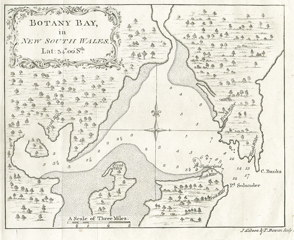
[media]Cook produced a sketch map of Botany Bay, [1] which shows the entrance area of the Georges River up to about Kangaroo Point. The river was mapped further by John Hunter, [2] the most senior naval officer in the First Fleet after Arthur Phillip (and the second governor of New South Wales), in 1789. Hunter's main task in Sydney was to survey the rivers and harbours. He spent 10 days surveying Botany Bay and the Georges River, [3] but was so unimpressed with the Georges River that he thought its map was only worth an 'eye sketch' upstream of a line from Sans Souci to Sylvania Waters. [4] Because of all its shallow areas, Hunter thought that the river was only suitable for boats, rather than the ships of his day. [media]His sketch went upstream to almost the junction with Little Salt Pan Creek and included a fair stretch of the Woronora River. A manuscript chart by William Bradley, held in the Dixson Map Collection of the State Library of New South Wales, is a copy of Hunter's chart. [5]
It is often stated that George Bass and Matthew Flinders were the first to map the Georges River. They, together with the young William Martin, sailed south to Botany Bay and the Georges River in a rowing boat, christened the Tom Thumb. They covered much the same ground in 1795 as Hunter had in 1789 but extended the survey up to about present-day Casula. To do so entailed going further upstream than even the little Tom Thumb could manage. The expedition lasted about nine days.
Subsequently they explored the coast from Sydney to Illawarra in a quite dangerous voyage in the Tom Thumb. [6] Their work was combined with other surveys in the 1799 New South Wales map of Charles Grimes and Matthew Flinders. [7] Bass and Flinders of course went on to carry out more extensive mapping expeditions. Grimes was acting Surveyor-General at the time and later filled that position from 1801 to 1811. [8] He carried out various surveys around Sydney, on Norfolk Island, on King Island and in Tasmania and discovered the Yarra River while surveying Port Phillip. A map of uncertain date in the Historical Records of New South Wales, titled 'Map of New South Wales by Charles Grimes 1806?,' shows the river to between present-day Prestons and Glenfield. [9] When the 1799 Grimes and Flinders map was updated in 1815, the course of Georges River was only extended as far south as Campbelltown, although the naturalist George Cayley [10] had explored the upper reaches of the river in 1807.
James Meehan was acting Surveyor-General from 1808 to 1812 and Deputy Surveyor-General, under John Oxley, from 1812 to 1823. Despite Governor Macquarie's recommendation he was not appointed Surveyor-General because he was an emancipated convict. He did much of the work of the survey department while Oxley went exploring. A couple of undated maps of Meehan's, held by the State Records Authority, show landholdings along the river – one from Voyager Point to a position between Prestons and Glenfield [11] and another around the head of Salt Pan Creek. [12] Both are in poor condition and have been used as base maps for updating land holdings and the latter even has railway lines added. The former has added annotations to at least 1954 and the latter to at least 1955.
Reliable maps emerge
The Georges River was resurveyed more extensively in 1827 [13] by Robert Dixon, assistant surveyor in the Surveyor-General's department from 1826 to 1836. [14] He also surveyed many areas in New South Wales and did some work around Moreton Bay. State Records Authority of New South Wales hold a couple of his maps, showing landholdings along the river in the Holdsworthy area. One showing a few properties was dated 1827 [15] and another showing more properties is undated. [16] Both show the river to a point just downstream of about Long Point.
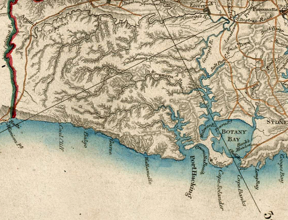
Surveyor-General Thomas Mitchell [17] combined surveys [media]from his Trigonometrical Survey of New South Wales, which involved work by numerous surveyors, among whom Dixon was prominent, to produce his 1834 Map of the Nineteen Counties. [18] While he was on leave in England in 1837 Dixon published an unauthorised map [19] of New South Wales, putting him in economic competition with Mitchell. Mitchell, Dixon's superior, was extremely angry.
Both these maps, based on the same survey data, showed the full length of the river. Mitchell's map emphasised the topography, while Dixon's emphasised landholdings. [20] The overall accuracy of these was a marked improvement on their predecessors. Attempting to overlay maps earlier than Meehan's on a modern one shows them to have not been very accurate and prominent features can only be matched approximately.
References
Bradley, William. A Voyage to New South Wales, the Journal of Lieutenant William Bradley RN of HMS Sirius, 1786–1792. Sydney: Trustees of the Public Library of New South Wales in association with Ure Smith, Sydney 1969.
Bladen, FM (Ed). Historical Records of New South Wales, vol 6, 1806–1808. Sydney: Charles Potter, Government Printer, 1892–1901. Facsimile. Mona Vale NSW: Lansdown Slattery, 1978–1979.
Curby, Pauline. Pictorial History of Sutherland Shire. Alexandria, NSW: Kingsclear Books, 2004.
Hunter, John. An historical journal of the transactions at Port Jackson and Norfolk Island with the discoveries which have been made in New South Wales and in the southern ocean since the publication of Phillip's voyage, compiled from the official papers, including the journals of Governors Phillip and King and of Lieut. Ball, and the voyages from the first sailing of the Sirius in 1787, to the return of that ship's company to England in 1792. Adelaide: Libraries Board of South Australia, 1968.
Notes
[1] A sketch of Botany Bay in New South Wales [cartographic material]: latitude 34 °00' S, Historical Records of New South Wales. Cook 1762–1780, vol 1, part 1 (Sydney: Charles Potter, Government Printer, 1893), available online at http://nla.gov.au/nla.map-rm2456d, viewed 4 June 2015
[2] JJ Auchmuty, 'Hunter, John (1737–1821)', Australian Dictionary of Biography, National Centre of Biography, Australian National University, http://adb.anu.edu.au/biography/hunter-john-2213/text2873, published in hardcopy 1966, viewed 5 February 2015
[3] William Bradley, A Voyage to New South Wales, the Journal of Lieutenant William Bradley RN of HMS Sirius, 1786–1792 (Sydney: Trustees of the Public Library of New South Wales in association with Ure Smith, 1969) pages 176 and 177
[4] John Hunter, An historical journal of the transactions at Port Jackson and Norfolk Island with the discoveries which have been made in New South Wales and in the southern ocean since the publication of Phillip's voyage, compiled from the official papers, including the journals of Governors Phillip and King and of Lieut. Ball, and the voyages from the first sailing of the Sirius in 1787, to the return of that ship's company to England in 1792, (Adelaide: Libraries Board of South Australia, 1968), 160 to 162 and 'Chart of the Coast between Botany Bay and Broken Bay surveyed in 1788 and 89 by Captain John Hunter', 160
[5] Chart of the coasts and harbours of Botany-Bay, Port-Jackson and Broken-Bay, as survey'd by Captn John Hunter of HMS Sirius, Dixson Map Collection, State Library of New South Wales, viewed online at http://library.sl.nsw.gov.au/record=b2168876~S2, viewed 4 June 2015
[6] Matthew Flinders, Narrative of voyages in the TOM THUMB Sep 1795–Apr 1796, up George's River and to Port Hacking (FLI/9/A), in Narrative of Voyages on the Tom Thumb and the Francez, 1795–1798 (FLI/9). Manuscript held in National Maritime Museum, Greenwich, UK.
[7] A topographical plan of the settlements of New South Wales, including Port Jackson, Botany Bay and Broken Bay [cartographic material] surveyed by Messrs. Grimes & Flinders, available online at http://library.sl.nsw.gov.au/record=b2071705~S2, viewed 4 June 2015
[8] Bernard T Dowd, 'Grimes, Charles (1772–1858)', Australian Dictionary of Biography, National Centre of Biography, Australian National University, http://adb.anu.edu.au/biography/grimes-charles-2129/text2699, published in hardcopy 1966, viewed 18 November 2014
[9] Map of New South Wales by Charles Grimes 1806?, in FM Bladen, ed, Historical Records of New South Wales, vol 6 – King and Bligh, 1806, 1807, 1808 (Sydney: William Applegate Gullick, Government Printer 1878
[10] R Else-Mitchell, 'Caley, George (1770–1829)', Australian Dictionary of Biography, National Centre of Biography, Australian National University, http://adb.anu.edu.au/biography/caley-george-1866/text2175, published first in hardcopy 1966, viewed online 5 March 2015
[11] Survey of Georges River area with farms and names of Landholders (now between Punchbowl Station and the East Hills-Tempe Railway Line). Annotations show land resumptions for railways, by James Meehan. State Records Authority of NSW: Survey General's Office, SR2737, SG Map G.321
[12] Map of the Georges River Basin, showing farms and names of Landholders, by James Meehan, State Records Authority of NSW, Surveyor General's Office, SR 2735, SG Map G286
[13] Helen McDonald, Como, Dictionary of Sydney, 2008, http://dictionaryofsydney.org/entry/como, viewed 1 January 2015
[14] Pauline Curby, Pictorial History of Sutherland Shire (Alexandria, NSW: Kingsclear Books, 2004); Louis R Cranfield, 'Dixon, Robert (1800–1858)', Australian Dictionary of Biography, National Centre of Biography, Australian National University, http://adb.anu.edu.au/biography/dixon-robert-1981/text2403, published in hardcopy 1966, viewed online 1 January 2015
[15] Two or three farms, including those of I Lucas, I Alford, Thomas Rowley, T Laycock and GH Evans, State Records Authority of NSW, Surveyor General's Office, SR 2733, SG Map G214
[16] Sketch of Parish of Holdsworthy, Shows land holdings along the Georges River, State Records Authority of NSW, Surveyor General's Office, SR 2977, SG Map H224
[17] DWA Baker, 'Mitchell, Sir Thomas Livingstone (1792–1855),' Australian Dictionary of Biography, National Centre of Biography, Australian National University, http://adb.anu.edu.au/biography/mitchell-sir-thomas-livingstone-2463/text3297, published first in hardcopy 1967, viewed online 10 March 2015
[18] To the Right Honorable Edward Geoffrey Smith Stanley this map of the Colony of New South Wales compiled from actual measurements with the chain & circumferenter, and according to a trigonometrical survey is (with the greatest respect), dedicated by his most obedient humble servant TL Mitchell, Surveyor General, (Sydney: 1834) available online at http://library.sl.nsw.gov.au/record=b2116501~S2, viewed 4 June 2015
[19] This map of the Colony of New South Wales exhibiting the situation and extent of the appropriated lands including the counties, towns, village reserves etc.: compiled from authentic surveys &c. is respectfully dedicated to Sir John Barrow Bart President of the Royal Geographical Society &c. &c. &c. by his obliged humble servant Robert Dixon, available online at http://library.sl.nsw.gov.au/record=b2281558~S2, viewed 4 June 2015
[20] John F Brock, 'A Tale of Two Maps – NSW in the 1830s by Mitchell and Dixon: Perfection, Probity and Piracy!' Paper No 5, (paper presented at Mapping Sciences Institute Conference on 100 Years of National Topographical Mapping, Darwin, 2006) available online at http://xnatmap.org/adnm/conf_06_11/c06/aPaper%2005.pdf, viewed 9 February 2015


