1. The Dictionary of Sydney
  2. Multimedia
  3. Parish of Willoughby, County of Cumberland c1846
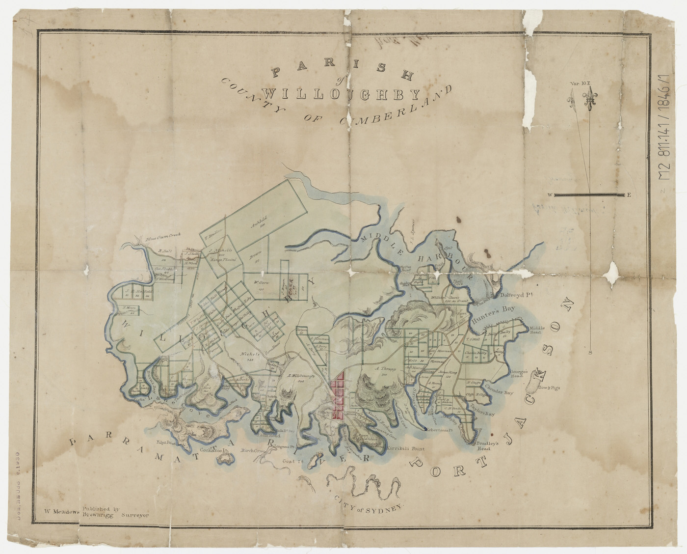
Parish of Willoughby, County of Cumberland c1846

By
William Meadows Brownrigg
From the collections of the
State Library of New South Wales
[M Z/M2 811.141/1846/1]
(Mitchell Library)

Browse

  • Browse
    • Artefacts
    • Buildings
    • Events
    • Natural Features
    • Organisations
    • People
    • Places
    • Structures
    • Entries
    • Multimedia
    • Subjects
    • Roles
    • Contributors
Connections
Subjects
Maps Rivers and Catchments Suburbanisation Urban sprawl
Places
Balls Head Blues Point Figtree Farm Greenwich Kirribilli Lane Cove Lavender Bay McMahons Point Middle Harbour Milsons Point Neutral Bay North Sydney St Leonards
Natural features
Balls Head Bay Blues Point Bradleys Head Chowder Bay Cockatoo Island Georges Head Goat Island Lane Cove River Little Sirius Cove Middle Harbour Middle Head Mosman Bay Parramatta River Port Jackson Sow and Pigs Reef

Footer

  • Home
  • About
  • Copyright
  • Contact

Footer Secondary

  • Contribute
  • Donate

Brownrigg, William Meadows

Surveyor, estate agent and lithographic printer. 

State Library of New South Wales

Maps

Rivers and Catchments

Suburbanisation

Urban sprawl

North Sydney

full record »

Sydney's second high-rise business district, at the northern end of the Sydney Harbour Bridge, result of a building boom from the 1960s to the 1980s.

Middle Harbour

Suburb on the north shore of Sydney, occupying the area south of the Spit Bridge.

full record »

Middle Harbour

An arm of Port Jackson, extending north-west from the Heads with its headwaters in Garigal National Park.

full record »

Port Jackson

full record »

Drowned river valley that forms Sydney Harbour and includes North Harbour and Middle Harbour. Long inhabited by the Gadigal, Cammeraygal, Wangal and Eora people, Port Jackson was renamed by Captain Cook in 1770, although his ship did not enter the Heads.

Parramatta River

full record »

Major tributary of Sydney Harbour, which flows east from Blacktown Creek to meet Port Jackson between Greenwich and Birchgrove. The river is tidal to Charles Street Weir at Parramatta, 30 kilometres from Sydney Heads.

Kirribilli

full record »

North Shore residential suburb built on Cammeraygal land in North Sydney local government area. Now containing the residences of the Prime Minister (Kirribilli House) and the Governor-General (Admiralty House), its uninterrupted views across the Harbour make it one of Sydney's most desirable suburbs.

McMahons Point

full record »

North shore harbourside suburb immediately to the west of the Sydney Harbour Bridge, named for Michael McMahon, a brush and comb manufacturer who settled there in the 1860s. Before the bridge was built, ferries from Circular Quay would meet trams there.

Blues Point

Headland on the northern shore of Sydney Harbour, named for boatman Billy Blue who was granted 80 acres there in 1817.

full record »

Blues Point

full record »

Locality on Sydney Harbour named for mariner Billy Blue.

Lane Cove

Affluent suburb on lower North Shore. Industry developed there in the nineteenth century, but lack of access to the district limited residential development until the early twentieth century.

full record »

Greenwich

full record »

Residential suburb on the north shore of Sydney Harbour, where the Lane Cove river joins the Parramatta River, named after shipbuilder George Green's Greenwich House. The Shell oil terminal has operated there since 1901.

St Leonards

Lower north shore suburb, named either after British statesman Lord Sydney of St Leonards, or by surveyor general Thomas Mitchell after the town in England. In recent years it has grown into a major business district, as well as being the location of the Royal North Shore Hospital.

full record »

Lavender Bay

Small harbourside suburb on Sydney's lower north shore between Blues Point and Milsons Point. The rail line running through it once terminated at the old Milsons Point station before the Sydney Harbour Bridge was built.

full record »

Milsons Point

Located on Sydney Harbour, adjacent to the northern approaches of the Sydney Harbour Bridge, Milsons Point played an important role in the development of the lower north shore.

full record »

Neutral Bay

Lower north shore harbourside suburb, named by Governor Phillip when he decreed in 1789 that all non-British 'neutral' ships visiting Port Jackson were to anchor there. Since the 1960s many apartment buildings and town houses have been built due to its desirable inner city location.

full record »

Cockatoo Island

full record »

Largest island in Sydney Harbour, between Birchgrove and Woolwich.

Goat Island

full record »

Referred to as 'Me-mel' ('eye') by Aboriginal people, Goat Island stands at the entrance to Darling Harbour.

Lane Cove River

Tributary of the Parramatta River, which rises near Thornleigh, flows south and drains to Port Jackson east of Greenwich Point. There are significant mangrove communities near where the river meets Sydney Harbour.

full record »

Middle Head

Headland in Sydney Harbour, now part of the Sydney Harbour National Park, which from 1806 to the 1960s contained important defensive fortifications.

full record »

Bradleys Head

Headland on the north shore of Sydney Harbour, now part of the Sydney Harbour National Park.

full record »

Little Sirius Cove

full record »

Cove at Mosman, to the east of Mosman Bay.

Mosman Bay

full record »

Sheltered bay on Sydney's north shore, named for Archibald Mosman, whaler. Earlier known as Great Sirius Cove after the HMS Sirius that was careened there in 1789.

Sow and Pigs Reef

Reef near the entrance to Sydney Harbour between Camp Cove and Georges Head. It caused damage and wrecks before explosives were used to reduce its size. In 1836 a lightship replaced the floating beacon, and this was in turn replaced by a permanent pile light in the 1912. The Western Channel Pile Light now marks the reef's western edge to guide shipping.

full record »

Figtree Farm

Mary Reibey's farm at Hunters Hill, which was rented for three years to Joseph Fowles, artist.

full record »

Chowder Bay

Bay on Sydney Harbour south of Georges Head. Named for the preferred food of the American whalers who used the area in the nineteenth century.

full record »

Georges Head

Headland on the southern side of Middle Head in Sydney harbour, now part of Sydney Harbour National Park.

full record »

Balls Head Bay

Home to a local Aboriginal community until 191, land was resumed during World War I and a Quarantine Depot established. The area is now zoned as open space.

full record »

Balls Head

Point on the Parramatta River west of McMahons Point. It was named after Lieutenant Henry Lidgbird Ball, who discovered Lord Howe Island in 1788.

full record »